Unit 1 · Topic 1.1 · about 30 minutes · 7 parts · 12 scored checks, 3 of them multiple choice
AP Human Geography 1.1: Introduction to Maps
Unit 1: 8 to 10% of the multiple-choice section
What you'll be able to do
- Identify reference maps and thematic maps and the kind of information each presents, read the spatial patterns maps show (absolute and relative distance and direction, clustering, dispersal and elevation), and explain why every map is selective and every map projection distorts shape, area, distance or direction.
Key vocabulary
| Term | What it means | The exam trap |
|---|---|---|
| Reference map | A map that shows where places and features are, such as boundaries, cities, roads and rivers, so a reader can find a location or plan a route. | Decide a map's type from what the map is for, not from one feature you happen to see on it. |
| Thematic map | A map that shows the spatial pattern of a particular topic, such as income, language or crop yields, across places. | Read the title and the legend to find the topic before you describe the pattern. |
| Absolute distance | Distance measured in a standard unit, such as kilometers or miles. | On a map it comes from the scale, so check what one unit on the map stands for before you measure. |
| Relative distance | How far apart places are in terms that matter to the people moving between them, such as travel time, cost or how well they are connected. | It can change when a road, bridge or bus line changes, even though the places themselves do not move. |
| Absolute direction | Direction given with the cardinal directions, north, south, east and west, and the directions between them. | Find which way north points on the map before you name a direction. |
| Relative direction | Direction given from a reference point that people share, such as left, uptown or toward the river. | It makes sense only to someone who knows the reference point it starts from. |
| Clustering | A pattern in which features sit close together in one or a few parts of an area. | Judge how the features are arranged, not how many of them there are. |
| Dispersal | A pattern in which features are spread out across an area, with space between them. | Look across the whole area the map covers before you call a pattern dispersed. |
| Elevation | Height above sea level, shown on maps with contour lines, shading or bands of color. | Read the numbers on contour lines; how close the lines sit and how high they are tell you different things. |
| Map projection | A method for drawing Earth's curved surface on a flat map. | Find out which of shape, area, distance and direction a projection keeps true before you compare places on it. |
 Tap to open the picture full size
Part 1 Think first Is the bus map wrong?
Pick an answer before you read on. A guess you have to revise is easier to remember than a fact you were handed.
Predict first
A transit agency in a hypothetical city prints a map of its bus lines. It draws each line as a straight colored band, marks every stop, and leaves out most streets, parks and buildings. To fit the whole system on one page, it also draws the outer suburbs closer to downtown than they really are. A rider complains that the map is wrong. Is the rider right?
In short. Maps come in two broad types, reference maps that show where places and features are and thematic maps that show the pattern of a topic, and both show spatial patterns such as distance, direction, clustering, dispersal and elevation, always selectively and, on a flat page, with some distortion.
- A reference map shows locations, such as boundaries, cities, roads and rivers; a thematic map shows how one topic varies from place to place, drawn on a base of boundaries or names.
- Absolute distance and direction use standard units and the cardinal directions; relative distance and direction depend on travel time, cost, connections or a shared landmark.
- Every map leaves things out for its purpose, and every map projection distorts at least one of shape, area, distance and direction.
Part 2 Learn it Four things to read on any map
2a. Reference maps and thematic maps
Every map is made for a purpose, and the purpose decides what goes on it. Geographers sort maps into two broad types.
A reference map shows where places and features are: boundaries, cities, roads, rivers, mountains. A road map, a map of a country's states and their capitals, and the map in a park brochure are reference maps. You use one to find a place or plan a route.
A thematic map shows the spatial pattern of a particular topic: income, crop yields, voting, languages, disease. It answers a question about how something varies from place to place. A thematic map still needs a base of boundaries or place names so readers know where they are looking, but the base is not its point; the topic is.
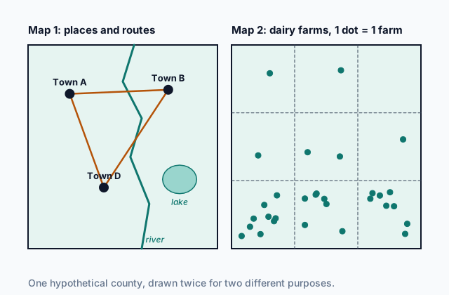
The two maps at the top of the page show the same hypothetical county. Map 1 is a reference map: towns, roads, a river and a lake. Map 2 is a thematic map: the same boundary, now divided into townships, with a dot for each dairy farm, so a reader sees at once where dairy farming is concentrated and where it is rare.
Quick check · Sort it
Each card describes a map. Tap a card, then the type of map it describes.
Reference map
Thematic map
2b. Distance and direction
Maps show where places are compared with one another, through distance and direction, and each comes in two forms.
Absolute distance is measured in a standard unit, such as kilometers or miles. A map's scale turns a measurement on the map into a distance on the ground: if 1 cm on a map stands for 5 km, two towns 3 cm apart on the map are 15 km apart.
Relative distance describes how far apart places are for the people who move between them: in travel time, in cost, or in how well they are connected. Two neighborhoods 2 km apart on opposite banks of a river with no bridge can be farther apart, in relative terms, than two neighborhoods 10 km apart on the same subway line.
Absolute direction uses the cardinal directions, north, south, east and west, and the ones between them, such as northwest. It reads the same for anyone holding the map.
Relative direction starts from a reference point the speaker and listener share: left, right, uptown, toward the mountains, past the school. It makes sense only to someone who knows that reference point.
Quick check · Match
Each statement tells a visitor where a hypothetical clinic is from a school. Match each term to the statement it describes.
2c. Clustering, dispersal and elevation
Maps also show how features are arranged across an area.
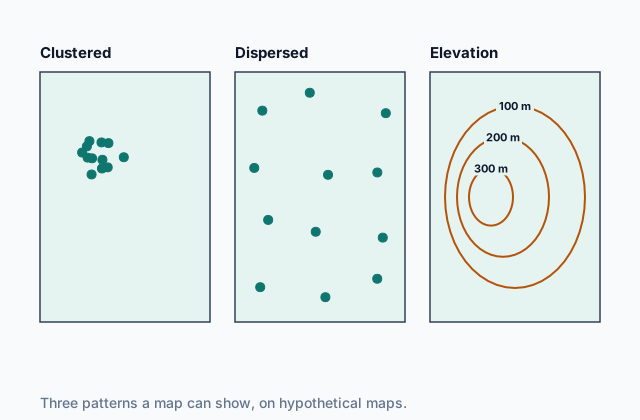
When features sit close together in one or a few parts of an area, the pattern is clustering: restaurants packed along one street, or houses grouped in a village with open farmland around it. When features are spread out across the area with space between them, the pattern is dispersal: farmhouses each standing on their own fields across a plain. The pattern describes the arrangement, not the number; ten features can be clustered or dispersed.
Elevation is height above sea level. Maps show it with shading, bands of color, or contour lines, each line joining points at the same elevation. Read the numbers on the lines to see which way the land rises. Lines close together mark steep land and lines far apart mark gentle land. A closed loop with higher numbers inside marks a hill. Elevation shapes human patterns too: settlements, roads and farms tend to avoid steep slopes, and travel over high ground is slower.
 Tap to open the picture full size
Quick check · Multiple choice
A map of hypothetical County V shows that 18 of its 20 car dealerships sit along a 2 km stretch of one highway, and that its 25 public schools are spread across the county, about one in each township. Which statement best describes the two patterns?
2d. Every map is selective, and every projection distorts
No map shows everything. A mapmaker chooses which features to include, which to leave out and how much detail to give, to suit the map's purpose. A subway map drops most streets; a map of crop yields drops the subway. Being selective does not make a map wrong, but a careful reader asks what was left out before drawing a conclusion.
Earth's surface is curved, and a curved surface cannot be laid flat without stretching or tearing it. A map projection is a method for drawing that curved surface on a flat map, and every projection distorts spatial relationships in at least one of four ways: shape, area, distance and direction. A projection can keep some of these true, but never all four across a large area.
- The Mercator projection keeps the shapes of small areas true, and the price is area: lands far from the equator look much bigger than they are.
- An equal-area projection, which shows every area at its true size, bends shapes, most of all toward the map's edges.
Distortion grows with the area a map covers: a world map distorts far more than a map of one town.
Quick check · Fill the statement
Complete the description of a world map made by a hypothetical mapmaker.
To draw the round Earth on a flat page, the mapmaker uses a . It keeps the shapes of small areas true, and in return it distorts . She also leaves out every road and city, because the map is for a lesson on coastlines; like every map, it is .
Part 3 Watch it done How far apart are two villages?
Follow each step, then finish the last one yourself.
On a hypothetical map, 1 cm stands for 5 km. Village P and Village Q sit on opposite shores of Lake M, also hypothetical. A straight line from P to Q measures 4 cm on the map. The only road between them runs around the lake and measures 9 cm. A bus averages 30 km per hour on that road. Find how far apart the villages are in absolute distance, and in relative distance measured as bus travel time.
Predict first
Before the steps: about how long do you expect the bus trip from P to Q to take?
Step 1 · Find the absolute distance
Absolute distance is measured in a standard unit, here kilometers, along the straight line. The line measures 4 cm, and each centimeter stands for 5 km: 4 × 5 = 20 km.
Step 2 · Find the road distance
The road bends around the lake and measures 9 cm on the map: 9 × 5 = 45 km. The bus has to cover more than twice the straight-line distance.
Why this step?
Why go on to the road and the travel time, when the absolute distance is already known?
No one in either village travels along the straight line, because the lake is in the way. Relative distance measures the separation people actually experience, here the time on the bus, and that can be much larger than 20 km suggests.
Your step · Calculate
How many minutes does the bus trip along the road from Village P to Village Q take?
minutes
Part 4 Try it Plan a mobile clinic
Try it · Decide and justify
The health office of hypothetical Pine County wants one map showing how the share of residents over age 65 changes from township to township, so it can decide where a mobile clinic should stop most often. Which kind of map should it make?
Which reason supports your answer?
Try it · Rank it
The mobile clinic parks in a hypothetical town and serves three villages. Rank the villages by relative distance to the clinic, measured as travel time, closest first. Work out each trip's time before you rank.
Shortest trip first
Give each one a place, 1 for first. Give two the same place if they are equal.
Your ranking: none yet
Part 5 Explain it Explain a map of hospital access
Nothing you write leaves this page. Compare your answer with the model and each scoring point.
Free response is 50% of the exam score. This one is shaped like Question 2, from free-response II.
Free-response practice · Question 2 style
Stimulus 1, a hypothetical map: the provinces of hypothetical Country K, each shaded by the percentage of its households that are within 10 km, in a straight line, of a hospital. The five provinces around the capital, in the northwest, are shaded darkest, over 90 percent. The four provinces of the south, where mountains rise above 2,000 m, are shaded lightest, under 40 percent. The map shows province boundaries, a north arrow and a scale bar, and no roads. All of its figures are invented.
(A) Identify the type of map shown in Stimulus 1.
(B) Describe the spatial pattern of hospital access the map shows.
(C) Explain how elevation could help account for the low hospital access in the south.
(D) Define relative distance.
(E) Explain why a household in the south that is within 10 km of a hospital in a straight line could still be far from it in relative distance.
(F) Describe one kind of information the map leaves out that a planner choosing a site for a new hospital would need.
(G) Explain why a flat map of Country K, like any flat map, distorts at least one of shape, area, distance or direction.
Model answer
(A) A thematic map. It shows the spatial pattern of one topic, hospital access, across the provinces.
(B) Access is highest in a cluster of provinces around the capital in the northwest, where over 90 percent of households are within 10 km of a hospital, and lowest in the mountainous south, under 40 percent.
(C) High, steep land holds fewer people, spread thinly in valleys, so fewer places have enough patients nearby to support a hospital. Building and staffing hospitals and roads on steep ground also costs more.
(D) Relative distance is how far apart places are for the people moving between them, measured in travel time, cost or connections rather than in a standard unit such as kilometers.
(E) The map measures a straight line, but people travel by road. In the mountains a road winds around ridges and climbs steep slopes, and it may close in bad weather, so a hospital 8 km away in a straight line can be an hour or more away by road.
(F) The map gives only a percentage for each province. A planner would also need where the existing hospitals are, where the roads run, or how many people live in each part of a province.
(G) Earth's surface is curved, and a curved surface cannot be flattened without stretching or tearing it. Every map projection therefore distorts at least one of these relationships. A map of one country distorts less than a world map, but not by zero.
Score your own answer. This is a self-check, not a grade. Tick each point your answer makes.
Part 6 Check yourself A planning map of County W
The first three questions use the County W map. The last two draw on the whole lesson.
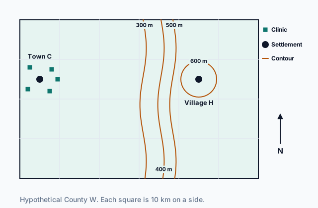
The planning office of hypothetical County W drew the map below to help choose a site for a new clinic. The map shows no roads. The office notes that the only road from Town C to Village H is 65 km long, a drive of about 80 minutes.
 Tap to open the picture full size
Case question 1 · Multiple choice
Which statement about elevation in County W does the planning office's map support?
Case question 2 · Calculate
On the planning office's map, Town C and Village H each sit at the center of a square, and Village H is due east of Town C. What is the absolute distance from Town C to Village H?
Case question 3 · Multiple choice
The planning office's map shows settlements, clinics and contour lines, but no roads, stores, houses or farm fields. Which statement best describes the map?
The rest stand on their own and do not use the case.
Check yourself · Spot the error
A student describes a map of hypothetical Elm County. Which line is the first to go wrong?
Check yourself · Select all
Which two statements about map projections are true? Select two.
Select 2 answers, then check.
Part 7 Keep it Bring back earlier ideas
This is the first lesson of the course, so there is nothing earlier to bring back yet. Later lessons will ask these questions again.
In three lines
- Reference maps show where places and features are; thematic maps show how one topic varies across places, drawn on a base of boundaries or names.
- Distance and direction are absolute in standard units and compass directions, relative in time, cost or landmarks; maps also show clustering, dispersal and elevation.
- Every map is selective, and every map projection distorts at least one of shape, area, distance and direction.
Exam strategy for this topic
- Section I, Multiple Choice: 60 questions in 60 minutes.
- Section II, Free Response: 3 questions in 75 minutes.
When a question shows a map, name its type and its purpose first, then describe the pattern with a place word in it, such as clustered in the northwest or dispersed across the plain. When a question asks how far, say whether you mean a straight-line distance or a distance in time or cost.
Questions students ask
What is the difference between a reference map and a thematic map?
A reference map shows where things are, such as cities, roads, rivers and boundaries, and you use it to find a place. A thematic map shows how one topic, such as income or language, varies across places. A thematic map is still drawn on a base of boundaries or names so readers know where they are looking.
Is relative distance always longer than absolute distance?
No. They are measured in different terms. A freeway or a rail line can make a far place quick to reach, and a river with no bridge can make a near place slow to reach. Relative distance describes the trip, and absolute distance describes the ground between the places.
Which map projection is the best one?
None is best for every job. Each projection keeps some of shape, area, distance and direction true and gives up others, so the right one depends on what the map is for, such as comparing the sizes of regions or plotting a course.
If every map leaves things out, can any map be trusted?
Yes, for the purpose it was made for. Leaving things out is what lets a map be read at all. A careful reader asks what the map was made to show and what it left out before drawing a conclusion from it.
Are the places in this lesson real?
No. Every county, town, village, lake, city and agency here is hypothetical, and every number is invented to show an idea clearly. The Mercator projection is a real, named projection type, used here as an example of one.
Course alignment, for teachers
AP Human Geography topic 1.1, Unit 1: Thinking Geographically.
- Skill 3.A: Identify the different types of data presented in maps and in quantitative and geospatial data.
This lesson maps all 3 essential knowledge statements of the topic to the part that teaches each one: 3 are checked by a scored question. The map is in the lesson file.