Unit 1 · Topic 1.4 · about 30 minutes · 7 parts · 12 scored checks, 3 of them multiple choice, plus 2 from earlier lessons
AP Human Geography 1.4: Spatial Concepts
Unit 1: 8 to 10% of the multiple-choice section
What you'll be able to do
- Define the major spatial concepts (absolute and relative location, space, place, flows, distance decay, time-space compression and pattern) and use each one to describe how places and the things in them relate to one another.
Key vocabulary
| Term | What it means | The exam trap |
|---|---|---|
| Absolute location | A position given exactly on a grid, usually latitude and longitude. | Write latitude before longitude, and give north or south and east or west with each number. |
| Relative location | Where a place is, described in relation to other places. | Name the other place the description is measured from, or the description is incomplete. |
| Space | The area of Earth's surface and the distances between the things in it. | In this course the word means area and distance here on Earth, not outer space. |
| Place | A location together with the physical and human characteristics that give it its own character. | Different people can describe the same place in very different ways, and each description can still be about place. |
| Flows | Movements of people, goods, money, ideas or information between places. | A flow runs from one place to another, so name both ends when you describe one. |
| Distance decay | The weakening of interaction between places as the distance between them grows. | It describes a trend across many trips, so one person who travels far does not disprove it. |
| Time-space compression | The shrinking of the time and cost of connecting distant places as transport and communication get faster and cheaper. | It does not reach every place equally; places off the new routes and networks can stay as remote as before. |
| Pattern | The arrangement of things across space, such as clustered, dispersed or linear. | Describing a pattern says how things are arranged, not why; explaining the cause is a separate step. |
 Tap to open the picture full size
Part 1 Think first Whose directions went stale?
Commit to a guess first. Being wrong now makes the right idea stick better.
Predict first
Two friends tell a visitor where the hypothetical town of Lake Ivy is. Ana reads its latitude and longitude off a GPS app. Ben says it is a 20-minute drive north of the county mall. A year later a new highway opens, and the drive from the mall to Lake Ivy takes 8 minutes. Whose description is now out of date?
In short. Spatial concepts are the ideas geographers use to describe where things are and how places relate to one another: absolute and relative location, space, place, flows, distance decay, time-space compression and pattern.
- Absolute location is a fixed position on a grid such as latitude and longitude; relative location is a position compared with other places, and it changes when the links between places change.
- Place is what a location is like, its physical and human characteristics; space is the area and the distances between things, and pattern is how things are arranged in that space, such as clustered, dispersed or linear.
- Flows are movements of people, goods and ideas between places; distance decay says interaction weakens as distance grows, and time-space compression says faster, cheaper links make distant places act closer.
Part 2 Learn it Eight ideas for describing where and how places relate
2a. Absolute and relative location
Location answers the question "where?" in two ways.
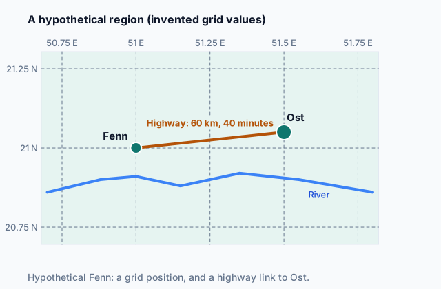
Absolute location is a position given exactly on a fixed grid, usually latitude and longitude, written latitude first. On the map at the top of the page, the hypothetical town of Fenn sits at 21 degrees north, 51 degrees east (invented values on an invented map). A GPS unit reports absolute location, and the position does not depend on anything around it.
Relative location describes where a place is compared with other places: its distance, direction, travel time or connections to them. Fenn is 40 minutes west of Ost by highway, just north of a river. Relative location often explains more about a place than its coordinates do, because it says what the place is near and linked to.
The two behave differently over time. Absolute location stays fixed. Relative location changes whenever the routes and places around a place change: a new bridge, a closed port, a city growing next door.
Quick check · Sort it
Each card says where something is in a hypothetical setting, with invented coordinates. Tap a card, then the kind of location it gives.
Absolute location
Relative location
2b. Place
Place is a location together with what makes it unlike anywhere else. Its physical characteristics include landforms, climate, soil and water. Its human characteristics include buildings, languages, religions, foods, jobs and festivals. Location says where; place says what is there and what it is like.
Take hypothetical Carrow, a fishing town. Its rocky harbor and cold morning fog are physical characteristics. Its painted wooden houses, its dockside fish auction and its yearly boat parade are human ones. Together they make Carrow a place, not just a dot on a map.
People also attach feelings and meanings to places. A family that has fished from Carrow for four generations and a tourist on a day trip may describe it very differently, and both descriptions are about place.
A place can change while its absolute location stays the same. If Carrow's fish auction closes and a cruise terminal opens in its place, the town sits at the same coordinates but becomes a different kind of place.
Quick check · Multiple choice
A travel writer is describing hypothetical Millbrook, a small river town. Which sentence describes Millbrook as a place?
2c. Space and pattern
Space is the area of Earth's surface and the distances between the things in it. A geographer studying space asks how far apart things are and how they are spread across an area: the 5 km of fields between two villages, or the land a city covers.
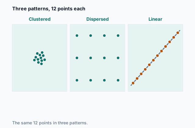
Pattern is the arrangement of things in space. The same number of things can be arranged in very different ways:
- Clustered: bunched close together, with empty space around the bunch, like restaurants packed around a hypothetical stadium.
- Dispersed: spread out across the area, far from one another, like a hypothetical county's fire stations, each placed to cover its own district. An even, regular spread is the most dispersed arrangement; some books call it uniform.
- Linear: lined up along a line, such as a road, river, coast or railroad, like towns strung along a hypothetical coastline.
Describing a pattern comes first, and explaining it comes after. The restaurants cluster where crowds gather; the coastal towns line up because the coast is where the harbors are.
 Tap to open the picture full size
Quick check · Fill the statement
A student describes a map of hypothetical Hollis County.
The county's gas stations all stand beside its one highway, one after another, a pattern. Its ranch houses stand far apart across the hills, each on its own land, a pattern. Measuring the 12 km of open range between two ranch houses is a question about .
2d. Flows, distance decay and time-space compression
Flows are movements between places: people commuting or migrating, trucks of goods, money, phone calls, ideas and information. Flows link places, so a map of flows shows which places depend on which.
Flows are not even. Distance decay is the weakening of interaction between places as the distance between them grows. Most of a hypothetical town library's borrowers live near it, and fewer come from each band farther out. Distance can be measured in kilometers, but also in travel time or cost, and people respond to the time and cost of a trip as much as to its length.
Time-space compression is the shrinking of the time, and often the cost, of connecting distant places as transport and communication get faster and cheaper. A trip that took a day by wagon takes an hour by car; a letter that took weeks is now an instant message. The kilometers have not changed, but the places act closer, so flows between them grow and distance decay weakens. Places off the new routes gain less.
Quick check · Decide and justify
Hypothetical towns Ardel and Bransk have the same population, and each is 50 km by road from City Q, the region's shopping center. Ardel's road is a new expressway, a 35-minute drive. Bransk's is a winding mountain road, a 90-minute drive. Which town would you expect to send more shopping trips to City Q for each resident?
Which reason supports your answer?
Part 3 Watch it done Do a market's shoppers fade with distance?
Watch each step, then do the last one yourself.
A hypothetical farmers market in the town of Ressa asks its Saturday shoppers where they live. Zone 1, within 10 km of the market, has 8,000 residents and sent 1,200 shoppers. Zone 2, from 10 to 30 km away, has 18,000 residents and sent 900 shoppers. Zone 3, from 30 to 60 km away, has 80,000 residents and sent 1,000 shoppers. Do the shoppers show distance decay?
Predict first
Before the steps, which zone do you expect sends the most shoppers for the number of people who live there?
Step 1 · Compare like with like
The zones hold very different numbers of people, so the raw counts (1,200, 900 and 1,000) cannot show whether interaction weakens with distance. Turn each count into a rate: shoppers ÷ residents × 1,000 gives shoppers per 1,000 residents.
Step 2 · Work out Zones 1 and 2
Zone 1: 1,200 ÷ 8,000 × 1,000 = 150 shoppers per 1,000 residents. Zone 2: 900 ÷ 18,000 × 1,000 = 50 shoppers per 1,000 residents.
Why this step?
Why not say Zone 3 interacts more with the market than Zone 2, since it sent 1,000 shoppers and Zone 2 sent 900?
Zone 3 has more than four times as many residents as Zone 2. A bigger count from a much bigger population can still mean each resident is less likely to come, and distance decay is about how likely interaction is, not how many people happen to live in a band.
Your step · Calculate
Finish it. A hypothetical market's farthest zone, 30 to 60 km away, has 80,000 residents and sent 1,000 shoppers. How many shoppers per 1,000 residents did that zone send?
shoppers per 1,000 residents
Part 4 Try it Describe new places
Try it · Match
A planner in the hypothetical island country of Tarrow writes four notes about the fishing town of Vell, using invented coordinates. Match each spatial concept to the note that uses it.
Try it · Multiple choice
A geographer maps the wells of a hypothetical desert village. Every well is about 400 m from its nearest neighbor, and none stand close together. Which statement best describes her finding?
Part 5 Explain it Explain where a warehouse's orders come from
Nothing you type leaves this page. Check your answer against the model and each scoring point.
Free response is 50% of the exam score. This one is shaped like Question 1, from free-response II.
Free-response practice · Question 1 style
A hypothetical grocery company delivers online orders from one warehouse at the edge of a hypothetical city. Vans drive each order from the warehouse to the customer's home.
(A) Define absolute location.
(B) Describe the warehouse's relative location in a way that would matter to the company.
(C) Explain why the warehouse's relative location can change even though its absolute location stays the same.
(D) Define distance decay.
(E) Explain how distance decay would shape where the warehouse's customers live.
(F) Describe time-space compression.
(G) A new expressway cuts the drive from the warehouse to a distant suburb from 50 minutes to 20 minutes. Explain one likely effect on the flow of orders from that suburb.
Model answer
(A) Absolute location is a place's exact position on a fixed grid, such as its latitude and longitude.
(B) The warehouse sits beside the ring road on the city's edge, about 15 minutes from downtown and close to the newer suburbs, so its vans can reach many homes quickly.
(C) Relative location depends on the places and routes around the warehouse. If a new road opens, a bridge closes or a new suburb is built nearby, its links to customers change, while its latitude and longitude stay fixed.
(D) Distance decay is the weakening of interaction between places as the distance between them grows.
(E) Customers close to the warehouse get faster, cheaper deliveries, so they are more likely to order. The share of households that order would be highest near the warehouse and fall off in neighborhoods farther away.
(F) Time-space compression is the shrinking of the time and cost needed to connect distant places as transport and communication improve, so places act closer even though they have not moved.
(G) Cutting the drive from 50 to 20 minutes makes the suburb closer in travel time, so distance decay is weaker there. Deliveries can arrive faster and cost the company less, so more households in the suburb would likely order, and the flow of orders from it would grow.
Score your own answer. This is a self-check, not a grade. Tick each point your answer makes.
Part 6 Check yourself Commuting into City R
The case questions use the table. The others mix the ideas from the whole lesson.
In a hypothetical region, a highway opened in 2018 linking City R to Towns J, K and L. Town M, in the hills, still reaches City R by an old road. The regional planning office reports these invented figures.
| Town | Road distance to City R | Trip time in 2010 | Trip time in 2025 | Workers commuting to City R, per 1,000 workers (2025) |
|---|---|---|---|---|
| J | 10 km | 15 min | 12 min | 300 |
| K | 25 km | 40 min | 22 min | 180 |
| L | 40 km | 70 min | 30 min | 110 |
| M | 60 km | 95 min | 85 min | 30 |
Case question 1 · Calculate
By what percent did Town K's trip time to City R fall from 2010 to 2025?
Case question 2 · Multiple choice
Which statement best describes the commuting figures for 2025?
Case question 3 · Spot the error
A student writes about Town L using the table. Which line is the first to go wrong?
The rest stand on their own and do not use the case.
Check yourself · Sort it
Each card describes a hypothetical situation. Tap a card, then the spatial concept it shows.
Distance decay
Time-space compression
Check yourself · Decide and justify
Over 30 years, the hypothetical town of Corley changes. Its textile mills close and their buildings become artists' studios, a yearly music festival begins, new houses spread onto farmland at the edge of town, and a bypass now carries highway traffic around the town instead of through it. Which of these did the changes alter?
Which reason supports your answer?
Part 7 Keep it Bring back earlier ideas
This lesson builds on geographic data from Topic 1.3 and maps from Topic 1.2.
From 1.3 The Power of Geographic Data · Calculate
A hypothetical clinic company will open its next clinic in whichever of three districts has the most residents aged 65 and over. Census data shows District 1 with 40,000 residents, 10% of them aged 65 and over; District 2 with 25,000 residents, 20% of them aged 65 and over; and District 3 with 60,000 residents, 5% of them aged 65 and over. How many residents aged 65 and over live in the district the company should choose?
From 1.2 Geographic Data · Fill the statement
Complete the description of how one region was studied.
A camera on an airplane photographs a hypothetical farming region from high above; gathering that photo is . A geographer studies the photo and writes that the fields are long, narrow strips running back from a river; her written reading is . Later she walks the region and writes what its barns, fences and churches suggest about the people who settled it; that is .
In three lines
- Absolute location is a fixed grid position; relative location is a position compared with other places, and it changes when links change.
- Place is what a location is like; space is the area and distances between things, and pattern is how they are arranged, such as clustered, dispersed or linear.
- Flows move people, goods and ideas; distance decay weakens interaction with distance, and time-space compression makes distant places act closer.
Exam strategy for this topic
- Section I, Multiple Choice: 60 questions in 60 minutes.
- Section II, Free Response: 3 questions in 75 minutes.
When a question names a spatial concept, define it in your own words and then tie it to the place or data in front of you. For location, say which kind you mean; for a pattern in a table or map, say which way it runs and over what distance.
Questions students ask
What is the difference between space and place?
Space is about area and distance: how far apart things are and how they are spread out. Place is about character: what a location is like, physically and in its people, buildings and activities.
Does time-space compression mean distance no longer matters?
No. Faster and cheaper links weaken distance decay, but nearby places still interact more than far ones in most cases, and places off the new routes gain little.
Why do geographers care about relative location if absolute location is more exact?
Absolute location finds a spot, but relative location explains much of what happens there: what a place is near, what it is linked to and how easily people and goods reach it.
Is a pattern the same as a region?
No. A pattern is how things are arranged across space, such as clustered or linear. A region is an area that geographers group together by a shared trait or by its links to a center, which a later topic in this unit covers.
Are the places and numbers in this lesson real?
No. Every town, city, island, country and figure here is hypothetical, and the coordinates are invented, chosen to show each concept clearly.
Course alignment, for teachers
AP Human Geography topic 1.4, Unit 1: Thinking Geographically.
- Skill 3.B: Describe spatial patterns presented in maps and in quantitative and geospatial data.
This lesson maps the one essential knowledge statement of the topic to the part that teaches each one: 1 is checked by a scored question. The map is in the lesson file.