Unit 3 · Topic 3.2 · about 30 minutes · 7 parts · 14 scored checks, 3 of them multiple choice
AP Human Geography 3.2: Cultural Landscapes
Unit 3: 12 to 17% of the multiple-choice section
What you'll be able to do
- Describe what a cultural landscape is made of, from physical features, farming, industry, religion and language to sequent occupance, traditional and postmodern architecture and land-use patterns.
- Explain how the features of a landscape and the way people use land and resources show their beliefs and identity, including attitudes toward ethnicity and gender, women's paid work, ethnic neighborhoods and indigenous communities and their lands.
Key vocabulary
| Term | What it means | The exam trap |
|---|---|---|
| Cultural landscape | The visible landscape of a place as its people have shaped, used and given meaning to it. | Describe what you can see in the landscape before you explain what it says about the people there. |
| Sequent occupance | The idea that each group that occupies a place leaves its imprint on the landscape, adding to what earlier groups left. | Look for clues on the landscape itself to tell which group left a feature. |
| Traditional architecture | Building in the way a group has long built in its region, often with local materials suited to the local climate. | It differs from region to region, so name the region when you describe it. |
| Postmodern architecture | A recent building style that mixes forms borrowed from older styles, such as columns and arches, with new materials, often in exaggerated or playful ways. | Similar postmodern buildings stand in many countries, so the style says less about one region than traditional building does. |
| Land-use pattern | The way the land in a place is divided and what each part is used for. | Read shapes on a map, such as strips or squares, as evidence of how the land was divided. |
| Ethnic neighborhood | An area of a city where many members of one ethnic group live, often marked by the group's places of worship, shops and language. | Name the features you can see before you say why the neighborhood formed. |
| Indigenous community | A group descended from the people who lived in a region before later settlers or states arrived there. | It is defined by descent and history, not by how its members earn a living today. |
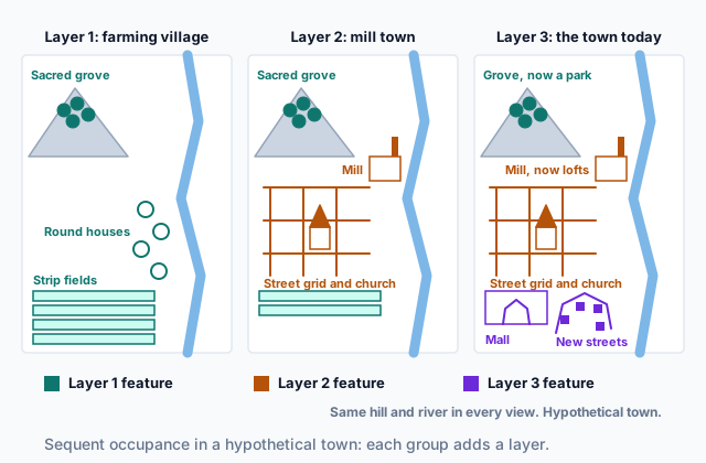 Tap to open the picture full size
Part 1 Think first What belongs in the picture?
Commit to a guess first. Being wrong now makes the right idea stick better.
Predict first
Ana, a geography student, photographs a hypothetical hill village. Her photo shows steep green hills, rice terraces stepped up their sides, a temple at the top of the village and street signs in two languages. Her teacher asks her to describe the village's cultural landscape. Which parts of the photo belong in her description?
In short. A cultural landscape is the visible combination of a place's physical features and the marks its people leave on them, from fields, factories and buildings to the way they divide and use land.
- It includes physical features, farming and industry, places of worship and language on signs and names, traditional and postmodern architecture, and land-use patterns.
- Under sequent occupance, each group that occupies a place adds a layer, and earlier layers often stay visible under or beside the new ones.
- Attitudes toward ethnicity and gender, including women's paid work, along with ethnic neighborhoods and indigenous communities and their lands, shape how a society uses space.
Part 2 Learn it Reading a cultural landscape
2a. What a cultural landscape is made of
A cultural landscape is a place seen as the work of the people who live there. It is a combination, never one thing alone. Geographers read these parts together:
- Physical features. Rivers, hills, coasts and climate belong, because people decide where to build, farm and gather around them.
- Agricultural and industrial practices. Terraced slopes, irrigation ditches, orchards in rows, mills, mines and rail yards.
- Religious and linguistic characteristics. Places of worship, shrines, cemeteries, signs in a language, and place names.
- Land-use patterns. How land is divided and what each piece is for: long strip fields or square lots, a market square at the center, homes kept apart from workshops.
Take hypothetical Brin Valley. A river cuts a narrow floor between dry slopes. Canals carry its water to rows of orchards, a canning factory stands by the bridge, a domed place of worship rises over the main street, and shop signs use two languages. No one of those parts is the cultural landscape. Read together, they show how one group has made the valley its own.
Quick check · Sort it
Each card is one feature of a hypothetical region's cultural landscape. Tap a card, then the part of the landscape it belongs to.
Physical feature
Agricultural or industrial practice
Religious or linguistic characteristic
2b. Layers over time, and the buildings in them
A landscape builds up over time. Sequent occupance is the idea that each group that occupies a place leaves its imprint, and later groups build on, around or over what came before. Some earlier features vanish. Many stay: a street name in a language few people still speak, a field edge that became a road, an old factory turned into apartments. Reading a landscape means looking for those layers. The picture at the top of the page shows three of them in one hypothetical river town.
Buildings are one of the clearest layers.
- Traditional architecture is built the way a group has long built in its region, often from local materials and suited to the local climate: thick clay walls that stay cool, steep roofs that shed snow, houses on stilts above floodwater. It differs from region to region, so it marks a place.
- Postmodern architecture is a recent style that came after the plain glass-and-steel boxes of modern architecture. It borrows old forms such as columns, arches and gables, sets them on new materials, and often makes them oversized or brightly colored on purpose. Similar postmodern buildings stand in many countries.
An old shape on a new building does not make the building traditional. Ask who built it, from what, and following whose custom.
Quick check · Fill the statement
Complete the description of a hypothetical lakeside town.
The town's oldest street still carries a name in the language of its first settlers, while a later group's factories now hold apartments, an example of . Its farmhouses of local clay, with thick walls built the way the region has always built, are architecture. Its new city hall, a glass building with a giant pink arch copied from an old temple, is architecture.
2c. Ethnicity, gender and the use of space
Who people are, and what a society expects of them, shapes where they go and what gets built.
Gender. Attitudes toward gender decide which spaces are seen as open to whom. Where custom expects women to stay near home, public spaces such as cafés or the main market may be used mostly by men, and houses may set rooms apart for women. As more women take paid work outside the home, the landscape changes: child care centers open near jobs and homes, shops stay open into the evening, and more ready-made food is sold to families with two working adults.
Ethnicity. An ethnic neighborhood is an area of a city where many members of one ethnic group live. You can see it: places of worship, shops selling the group's foods, signs in its language, festivals in the street. Such neighborhoods form for two kinds of reasons. Newcomers choose to live near people who share their language and faith and can help them find work and housing. And discrimination, such as landlords refusing to rent to the group, can leave its members few other places to live.
In hypothetical City K, three blocks of bakeries, a temple and street signs in two languages grew up where one group of migrants first found rooms to rent.
Quick check · Select all
In hypothetical City H, which two observations show attitudes toward gender shaping the use of space? Select two.
Select 2 answers, then check.
2d. Indigenous communities and their lands
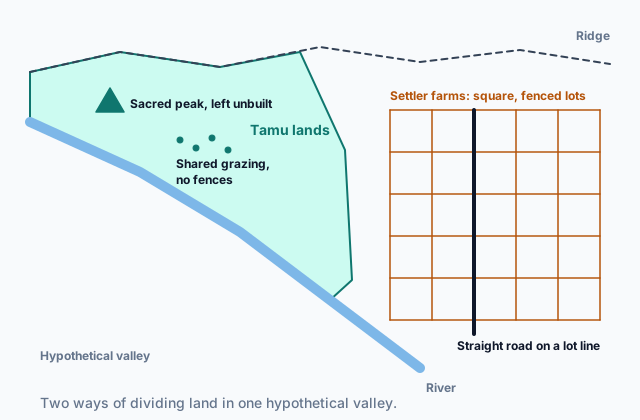
An indigenous community is a group descended from the people who lived in a region before later settlers or states arrived. Its use of land often reflects long-held beliefs. A peak or a grove may be sacred and left unbuilt. Land may be held by the whole community instead of being split into private lots, and herds or harvests may move with the seasons. Place names in the group's language record what each spot means.
When settlers arrive with different beliefs about land, the landscape shows the clash. In many places settlers surveyed land into square lots, fenced it and sold it to owners, with straight roads along the lot lines. Indigenous communities were often pushed onto smaller areas, sometimes called reserves or reservations. Some of those communities now work to win back land or to protect sacred sites from mines, dams and resorts.
Unbuilt land is not unused land. A sacred mountain with no roads on it reflects a choice that comes from belief, and it is part of the cultural landscape as surely as a city street.
The map shows a hypothetical valley where both ways of dividing land sit side by side. Read it the way you would read any landscape: look at the shapes of the boundaries, what is left open and what is fenced.
 Tap to open the picture full size
Quick check · Sort it
A map of a hypothetical valley shows two areas. The Tamu lands, an indigenous community's area, have an irregular outline along the river and the ridge, with a sacred peak that has no roads or buildings and shared grazing with no fences. Beside them, settler farms are square, fenced lots with a straight road along a lot line. Tap each pattern, then the group whose beliefs about land it reflects.
Reflects Tamu beliefs
Reflects settler beliefs
Part 3 Watch it done Read the layers of a waterfront
Watch each step, then do the last one yourself.
Hypothetical Port Alder was founded by fishing families who spoke Language X; few people in the town speak it today. A student walking the waterfront records five features: a glass office tower whose entrance borrows a pointed arch from old church buildings; rail tracks along the loading doors of the warehouses, laid at the same time the warehouses were built; street names in Language X; brick warehouses standing on land that was filled in over most of the old beach; and three wooden boat sheds that the founding fishing families built, older than any brick building in town, on the strip of beach that was never filled. Sort the features into the layers of Port Alder's sequent occupance.
Predict first
Before the steps, which feature do you expect belongs to the oldest layer of Port Alder's waterfront?
Step 1 · List what each feature is
Five features, left by the groups that used the waterfront in turn: an office tower, rail tracks, street names, warehouses and boat sheds. No dates are written on any of them, so the order has to come from clues in the description and on the landscape.
Step 2 · Place one feature from a clue
The street names are in Language X, the language of the fishing families who founded the town. Names are easy to keep and hard to change, so they often outlast the people who gave them. The street names belong to the first layer.
Why this step?
Why look at what each feature stands on and who built it?
A feature built on land filled in over an older one must be younger than what stood there, and features built at the same time belong to the same layer. Where nothing is dated, what a feature stands on and who built it are the evidence of order.
Your step · Rank it
Finish it. Rank the five features of hypothetical Port Alder's waterfront by layer, earliest first. Give features from the same layer the same place.
Earliest layer first; features from the same layer share a place
Give each one a place, 1 for first. Give two the same place if they are equal.
Your ranking: none yet
Part 4 Try it Read a mountain town and a sacred peak
Try it · Match
Hypothetical Vell is a mountain town. Match each idea about cultural landscapes to the feature of Vell that shows it.
Try it · Decide and justify
In a hypothetical mountain region, the Tava people, an indigenous community, have never built on Mount Ores, which they hold sacred; they climb it only for ceremonies. A resort company calls the mountain empty land and asks to build ski lifts on it. Is the unbuilt mountain part of the region's cultural landscape?
Which reason supports your answer?
Part 5 Explain it Explain a town's landscape
Nothing you type leaves this page. Check your answer against the model and each scoring point.
Free response is 50% of the exam score. This one is shaped like Question 1, from free-response II.
Free-response practice · Question 1 style
Hypothetical Harlow Bay is a coastal town. The Sela people, an indigenous community, fished the bay for generations and hold the headland above it sacred. Later settlers built a fish cannery, a church and a grid of streets. Today the cannery is a museum, a postmodern hotel stands on the waterfront, and a neighborhood of immigrants from hypothetical Country T has grown up near the old cannery.
(A) Identify one physical feature that is part of Harlow Bay's cultural landscape.
(B) Describe sequent occupance, using Harlow Bay as the example.
(C) Describe one way the postmodern hotel differs from traditional architecture.
(D) Explain how the Sela people's beliefs could shape the use of the headland.
(E) Describe one feature of the landscape that would show the Country T neighborhood is an ethnic neighborhood.
(F) Explain one reason the immigrants from Country T may have settled close together.
(G) Explain how more women taking paid jobs at the hotel and the museum could change the use of space in Harlow Bay.
Model answer
(A) The bay, or the headland above it.
(B) Sequent occupance means each group that occupies a place leaves its own layer, and later layers are added beside or on top of the earlier ones. In Harlow Bay, the Sela people's sacred headland, the settlers' church and grid of streets, the old cannery and today's hotel can all be seen at once.
(C) Traditional architecture is built from local materials in the way the region has long built. The postmodern hotel uses new materials such as glass and steel and borrows old forms, such as columns or gables, on purpose, in a style found in many countries.
(D) Because the Sela hold the headland sacred, they may leave it unbuilt and use it only for ceremonies, and they may oppose plans to put roads or houses on it.
(E) Shops with signs in Country T's language, or a place of worship of the immigrants' faith.
(F) Through chain migration, the first immigrants from Country T helped relatives and friends find housing and work near them, so later arrivals settled in the same few streets.
(G) With more mothers in paid work, families need care for young children during work hours, so child care centers may open near the hotel, the museum and the neighborhoods, and stores may stay open later or sell more ready-made meals.
Score your own answer. This is a self-check, not a grade. Tick each point your answer makes.
Part 6 Check yourself The surveys of Mill Road
The case questions use the table. The others mix the ideas from the whole lesson.
A planner in the hypothetical town of Carrow counted the features along Mill Road in three surveys, each about twenty years apart. Group A is the town's older population; Group Z arrived later from another country. The last row covers all of Carrow.
| Feature | Survey 1 | Survey 2 | Survey 3 |
|---|---|---|---|
| Working textile mills | 3 | 3 | 0 |
| Old mill buildings turned into apartments | 0 | 0 | 3 |
| Places of worship of Group A | 1 | 1 | 1 |
| Places of worship of Group Z | 0 | 0 | 1 |
| Shops (of 30) with signs in Group Z's language | 0 | 6 | 21 |
| Child care centers | 0 | 1 | 5 |
| Women aged 25 to 54 in paid work, all of Carrow (percent) | 20 | 35 | 65 |
Case question 1 · Multiple choice
Which statement about Mill Road is best supported by the table?
Case question 2 · Decide and justify
A reporter writes that by Survey 3, Mill Road had become an ethnic neighborhood of Group Z. Does the table support the reporter?
Which evidence from the table supports your answer?
Case question 3 · Multiple choice
Which is the best explanation for the change in child care centers on Mill Road across the three surveys?
The rest stand on their own and do not use the case.
Check yourself · Spot the error
A student describes the buildings of a hypothetical valley town. Which line is the first to go wrong?
Check yourself · Select all
Which two help explain why an ethnic neighborhood forms in a hypothetical city? Select two.
Select 2 answers, then check.
Part 7 Keep it Bring back earlier ideas
This lesson stands on attitudes toward cultural difference from Topic 3.1 and on the types of voluntary migration, such as chain migration, from Topic 2.11.
Bring it back · Multiple choice
A traveler in hypothetical Country M sees families eat their main meal late at night. She tells a friend that this custom is wrong because it differs from the custom where she grew up. Which attitude toward cultural difference does she show?
Bring it back · Fill the statement
Two kinds of voluntary migration in a hypothetical country.
Herders who move their animals to mountain pastures each summer and back to valley pastures each winter practice . Migration in which people follow relatives or friends who moved to a place before them is called migration.
In three lines
- A cultural landscape combines physical features, farming and industry, religion and language, architecture and land-use patterns.
- Sequent occupance: each group adds a layer, and older layers often stay. Traditional architecture follows regional custom; postmodern borrows old forms on new materials.
- Attitudes toward ethnicity and gender, women's paid work, ethnic neighborhoods and indigenous lands all shape how a society uses space.
Exam strategy for this topic
- Section I, Multiple Choice: 60 questions in 60 minutes.
- Section II, Free Response: 3 questions in 75 minutes.
When a question shows or describes a landscape, point to one specific feature first, then say what belief, identity or period it reflects. Name the feature and its meaning together.
Questions students ask
Is a river or a mountain part of a cultural landscape?
Yes. Geographers count physical features as part of the cultural landscape, because people decide how to settle, farm, build around or protect them. What matters is the combination of the land and what people have done with it.
Does sequent occupance mean the newest group replaces everything before it?
No. Some earlier features disappear, but many stay: place names, field edges, old buildings put to new uses. Reading a landscape means finding those older layers beside the new ones.
What is the difference between traditional and postmodern architecture?
Traditional architecture follows a region's long building custom, often with local materials suited to the climate, so it differs from place to place. Postmodern architecture is a recent style that borrows old forms such as arches and columns, sets them on new materials and often exaggerates them; similar postmodern buildings appear in many countries.
How does women's paid work show up on a landscape?
When more women work outside the home, families need care and services during work hours. Child care centers open near homes and jobs, stores stay open later, and more ready-made food is sold.
Are the places in this lesson real?
No. Every town, valley, community and country here is hypothetical, with features chosen to show each idea clearly. Real landscapes mix these ideas more loosely.
Course alignment, for teachers
AP Human Geography topic 3.2, Unit 3: Cultural Patterns and Processes.
- Skill 4.B: Describe the spatial patterns presented in visual sources.
This lesson maps all 2 essential knowledge statements of the topic to the part that teaches each one: 2 are checked by a scored question. The map is in the lesson file.