Unit 4 · Topic 4.1 · about 30 minutes · 7 parts · 14 scored checks, 3 of them multiple choice
AP Human Geography 4.1: Introduction to Political Geography
Unit 4: 12 to 17% of the multiple-choice section
What you'll be able to do
- Define the types of political entities on the world political map, from the independent state to the nation, nation-state, stateless nation, multinational state, multistate nation and autonomous or semiautonomous region, and identify an example of each, such as a Native American reservation.
Key vocabulary
| Term | What it means | The exam trap |
|---|---|---|
| Independent state | A territory with a permanent population, set borders and a government that has sovereignty over it; what most people call a country. | In the United States, state also names a division inside the country, so check which meaning a sentence uses. |
| Sovereignty | A state's final authority over its own territory, with no outside power above its government. | Ask who has the final say, not who runs the day-to-day. |
| Nation | A group of people who share a culture, such as a language, religion or history, and see themselves as one people, usually tied to a homeland. | Check whether a sentence uses the word in its everyday sense or its geographic one. |
| Nation-state | A state whose borders match the homeland of one nation, with most of its people belonging to that nation. | A government of its own makes a state, not a nation-state; compare the borders with the homelands. |
| Multinational state | A state whose borders hold the homelands of two or more nations. | It describes a state, never a people. |
| Multistate nation | A nation whose people live in two or more states, whether or not one of those states is its own. | It describes a people, never a state. |
| Stateless nation | A nation that has no state of its own. | Ask whether any state is the nation's own before you use the term. |
| Autonomous region | A region inside a state with its own government and wide powers over its affairs; a semiautonomous region has fewer such powers. | The state it sits in keeps sovereignty over it. |
 Tap to open the picture full size
Part 1 Think first Count the states and the nations
Commit to a guess first. Being wrong now makes the right idea stick better.
Predict first
On a hypothetical island, one government makes the laws for the whole island, and no other country can overrule it. Four peoples live there. Each speaks its own language, tells its own stories of the past and calls a different part of the island home. How many states and how many nations are on the island?
In short. Political geography starts from the independent state, a territory whose government answers to no outside power, and compares it with the nation, a people who share a culture and see themselves as one.
- Independent states, each with sovereignty over its own territory, are the building blocks of the world political map.
- A nation is a cultural group; where one nation's homeland matches one state's borders, the state is a nation-state.
- Where they do not match, there are multinational states, multistate nations and stateless nations, and some peoples govern part of their own affairs inside a state, in autonomous and semiautonomous regions such as Native American reservations.
Part 2 Learn it The pieces of the political map
2a. Independent states
Look at a world political map and almost every piece of land is colored as part of one country. Geographers call each of these an independent state, or simply a state: a territory with a permanent population, set borders and a government that has sovereignty, final authority over that territory with no outside power above it. Other states recognize it and deal with it as an equal, through trade and treaties.
Independent states are the primary building blocks of the world political map. Nearly all land is divided among them; Antarctica is the main exception. Every smaller unit on the map, a province, a county, a reservation, sits inside a state.
Two warnings. Size does not decide it: a small island state is as much a state as a huge one. And the everyday word can mislead you. The fifty states of the United States are divisions inside one independent state; under the Constitution none of them can make a treaty with another country or coin its own money. When geographers say state, they mean the country.
Quick check · Sort it
Each card describes a hypothetical place. Tap a card, then the bin it belongs in.
An independent state
Not an independent state
2b. Nations and nation-states
A nation is a different kind of thing: a group of people who share a culture, such as a language, a religion, a history or customs, and who see themselves as one people, usually with a homeland they feel is theirs. A state is political; a nation is cultural. Everyday speech blurs the two ("the nation's capital"), but geographers keep them apart.
When a state's borders match the homeland of one nation, and most of its people belong to that nation, the state is a nation-state. Its people feel that their culture and their government belong together, and the government often uses that shared identity in its schools, holidays and symbols.
Few states fit the idea perfectly. Almost every state has some people from other places, through migration or through borders drawn long ago. So nation-state describes a close match between one nation and one state, not a population with no newcomers at all. What would break the match is a second nation with its own homeland inside the borders.
Quick check · Decide and justify
In hypothetical Country Velm, nearly everyone speaks the national language, shares one history and calls themselves Velmish, and the Velmish homeland lies entirely inside Velm's borders. A few thousand recent immigrants also live there. Which term fits Velm?
Which reason supports your answer?
2c. When nations and states do not match
Borders and homelands often fail to line up, and geographers have a term for each kind of mismatch.
A multinational state holds the homelands of two or more nations inside one set of borders. Belgium, where Dutch-speaking Flemings and French-speaking Walloons each have their own region, is one. Canada, home to French-speaking Québécois and many First Nations as well as English-speaking Canadians, is another.
A multistate nation is one nation whose people live in two or more states, whether or not one of those states is its own. Sometimes a border runs through its homeland; sometimes part of a nation lives next door to the state that is its own.
A stateless nation has no state of its own. Its people may want one, but their homeland lies inside one or more states run by other peoples.
The terms answer different questions, so one case can need more than one of them. For any nation, ask two things: does it have a state of its own, and how many states do its people live in? For any state, ask how many nations have homelands inside it.
Quick check · Sort it
Each card describes a hypothetical people or state. Tap a card, then the term that fits it.
Multinational state
Multistate nation
Stateless nation
2d. Autonomous and semiautonomous regions
Some regions inside a state govern part of their own affairs. An autonomous region has its own government with wide powers granted by the state, such as running its own schools, courts or taxes. A semiautonomous region governs some of its own affairs, usually fewer. In both, the state keeps sovereignty: the army, dealings with other countries and the final say stay with the national government, and the region is not a separate state on the world map.
Native American reservations in the United States are an example. On a reservation, a tribe's own government runs many affairs, such as tribal courts, land use and who counts as a member, and federal law recognizes tribes as governing their own internal affairs. But reservations lie inside the United States, which handles defense and relations with other countries, so they are not independent states. US law speaks of tribal sovereignty: tribes keep a limited power to govern themselves inside the United States. It is not the full sovereignty of an independent state.
Regions like these often belong to one nation within a multinational state. They give a people a measure of self-rule without drawing a new border on the world map.
Quick check · Spot the error
A student explains the political status of the hypothetical Hollin Reservation. Which line is the first to go wrong?
Part 3 Watch it done Classify the map's states and nations
Watch each step, then do the last one yourself.
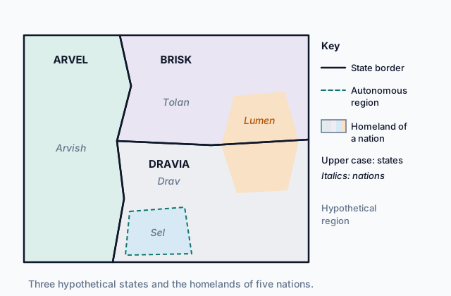
The map at the top of the page shows a hypothetical region. In Arvel, the Arvish run the national government; in Brisk, the Tolan do; and in Dravia, the Drav do. Use the map to classify Arvel, Dravia and the Lumen people.
Predict first
Before the steps, how many of the three states on the map do you expect to be nation-states?
Step 1 · Read the key
Solid lines are state borders, so the region has three independent states: Arvel, Brisk and Dravia. Shading and italic names show the homelands of five nations. The dashed line marks the Sel Autonomous Region, which lies inside Dravia and is part of it, not a fourth state.
Step 2 · Compare Arvel's borders with the homelands
Only one homeland lies inside Arvel, the Arvish one, and it stops at Arvel's borders. One nation's homeland matches one state's borders, so Arvel is a nation-state.
Step 3 · Do the same for Dravia
Dravia's borders hold the Drav homeland, the Sel homeland and the southern part of the Lumen homeland. Several nations have homelands inside one state, so Dravia is a multinational state. The Sel run some of their own affairs in their autonomous region, but Dravia keeps sovereignty over it.
Why this step?
Why compare the homelands with the borders, instead of asking only which government rules each area?
A state is defined by its government and borders, a nation by its culture and homeland. Each term for a state or a nation describes how those two layers fit together, so you need both layers of the map.
Your step · Select all
Finish it. Using the map and the problem, which two terms describe the Lumen? Select two.
Select 2 answers, then check.
Part 4 Try it Read a political map
A teacher hands out a political map of the hypothetical Country Tessa and its neighbor, Country Oss. Tessa contains the Hollin Reservation and the large Dunmore Province. Most of Tessa is the homeland of the Tessans, and the Kesh people live on both sides of the Tessa and Oss border.
Try it · Match
Match each mark on the map to the information it gives.
Try it · Decide and justify
Country Oss has fewer people and less land than Tessa's Dunmore Province. Which of the two is one of the building blocks of the world political map?
Which reason supports your answer?
Part 5 Explain it Explain the peoples of a state
Nothing you type leaves this page. Check your answer against the model and each scoring point.
Free response is 50% of the exam score. This one is shaped like Question 1, from free-response II.
Free-response practice · Question 1 style
Hypothetical Country Rastan is an independent state. The Rast, the Oda and the Kiri live in Rastan, each in its own homeland. The Rast, the largest group, run the national government. The Oda live in Rastan's northern hills, and their homeland continues across the border into neighboring Country Vey; the Oda run neither Rastan nor Vey. The Kiri homeland in the south is the Kiri Autonomous Region, with its own elected council.
(A) Identify the type of political entity Rastan is.
(B) Describe the difference between a nation and a state.
(C) Explain why the Oda are a multistate nation.
(D) Describe one power the Kiri council could hold and one power that stays with Rastan's national government.
(E) Explain why independent states, rather than nations or regions, are the building blocks of the world political map.
(F) Explain why the Oda are also a stateless nation.
(G) Explain why Rastan is not a nation-state, even though one nation runs its government.
Model answer
(A) Rastan is a multinational state.
(B) A nation is a group of people who share a culture, such as a language and a history, and see themselves as one people. A state is a political unit: a territory whose government has sovereignty over it.
(C) The Oda homeland crosses the border, so Oda people live in two states, Rastan and Vey. One nation spread across more than one state is a multistate nation.
(D) The Kiri council could run the region's schools. Rastan's national government keeps control of the army.
(E) States hold sovereignty, and nearly all the world's land is divided among them. Nations and autonomous regions sit inside states or across their borders and have no final authority of their own, so they are drawn within the map of states.
(F) The Oda run neither of the states their homeland lies in, so they have no state of their own, which makes them a stateless nation.
(G) A nation-state's borders match the homeland of one nation. Rastan's borders hold three homelands, the Rast, Oda and Kiri ones, so the Rast running the government does not make Rastan a nation-state.
Score your own answer. This is a self-check, not a grade. Tick each point your answer makes.
Part 6 Check yourself The peoples of Country Halvar
The case questions use the table. The others mix the ideas from the whole lesson.
Hypothetical Country Halvar is an independent state. A government report describes the four peoples who live there.
| People | Where they live | Political status |
|---|---|---|
| Halvari | Central lowlands; their homeland lies wholly inside Halvar | Run Halvar's national government |
| Moro | Northern hills; their homeland continues across the border into Country Tess | Run neither Halvar nor Tess |
| Tirri | Southern coast; their homeland lies wholly inside Halvar | Run the Tirri Autonomous District's council, which controls schools and land use |
| Teskans | Towns along Halvar's western border with Country Tess | Most Teskans live in Country Tess, where they run the government |
Case question 1 · Multiple choice
Which term best describes Halvar?
Case question 2 · Multiple choice
Which statement about the Moro does the table support?
Case question 3 · Select all
Which two peoples in the table are multistate nations? Select two.
Select 2 answers, then check.
The rest stand on their own and do not use the case.
Check yourself · Fill the statement
A report on the hypothetical Country Oren uses the terms of political geography.
Oren's government answers to no outside power, so Oren is a . The Orenish share a language and a history and see themselves as one people, so they are a . Oren's borders match the Orenish homeland, and most of its people are Orenish, so Oren is a .
Check yourself · Rank it
Rank these three hypothetical places by how much they govern their own affairs.
Most self-government first
Give each one a place, 1 for first. Give two the same place if they are equal.
Your ranking: none yet
Part 7 Keep it Bring back earlier ideas
Two questions from Unit 3 to keep them fresh: the effects of diffusion (Topic 3.8) and its contemporary causes (Topic 3.6).
Bring it back · Multiple choice
Immigrants from hypothetical Country Pell settle in a city in hypothetical Country Rhee. Twenty years later, their children speak Rhee's language at school and the families dress in Rhee's styles, but at home they still mark Pell's religious holidays. Which effect of cultural diffusion does this describe?
Bring it back · Fill the statement
Two cousins, one in hypothetical Country Abra and one in hypothetical Country Zell, send each other messages every day.
Their messages arrive in seconds, where a letter once took weeks, an example of . As teenagers in both countries follow the same online music channels, their tastes grow more alike, an example of cultural .
In three lines
- Independent states, each with sovereignty over its territory, are the building blocks of the world political map.
- A nation is a people with a shared culture; a nation-state is a state whose borders match one nation's homeland.
- Multinational states, multistate nations and stateless nations are mismatches of state and nation; autonomous regions and reservations govern some affairs inside a state.
Exam strategy for this topic
- Section I, Multiple Choice: 60 questions in 60 minutes.
- Section II, Free Response: 3 questions in 75 minutes.
When a question names a place or a people, first decide whether it is a state (a government and its territory) or a nation (a people and its homeland). Then pick the term that says how the two fit.
Questions students ask
Is a country the same as a state?
In political geography, yes: an independent state is what most people call a country. The fifty states of the United States are not states in this sense; they are divisions inside one.
Is any state a perfect nation-state?
Very few, if any. Nearly every state has some people from other places, so nation-state describes a close match between one nation's homeland and one state's borders.
Are Native American reservations independent?
No. Tribal governments run many of their own affairs, such as courts and land use, but reservations lie inside the United States, which keeps final authority over defense and relations with other countries.
What is the difference between an autonomous and a semiautonomous region?
Both govern some of their own affairs inside a state. An autonomous region usually holds wider powers and a semiautonomous one fewer. In both, the state keeps sovereignty.
Are the places in this lesson real?
The countries, peoples and regions in the map, the scenarios and the questions are hypothetical. Belgium, Canada, the United States and Native American reservations, named in the teaching, are real.
Course alignment, for teachers
AP Human Geography topic 4.1, Unit 4: Political Patterns and Processes.
- Skill 4.A: Identify the different types of information presented in visual sources.
This lesson maps all 2 essential knowledge statements of the topic to the part that teaches each one: 2 are checked by a scored question. The map is in the lesson file.