Unit 4 · Topic 4.2 · about 30 minutes · 7 parts · 14 scored checks, 3 of them multiple choice
AP Human Geography 4.2: Political Processes
Unit 4: 12 to 17% of the multiple-choice section
What you'll be able to do
- Explain how sovereignty, nation-states and self-determination, along with colonialism, imperialism, independence movements and devolution along national lines, have shaped contemporary political boundaries.
Key vocabulary
| Term | What it means | The exam trap |
|---|---|---|
| Sovereignty | A state's final authority over its own territory, with no outside power able to overrule its government. | Ask who could take the power back before you call it sovereignty. |
| Self-determination | The idea that a people, especially a nation, has the right to choose its own government and political future. | It is a claim a people makes, not a power a state holds. |
| Imperialism | One state extending its power over other peoples and territories, by conquest, trade or direct rule. | It is the wider idea; colonialism is one form of it. |
| Colonialism | A state taking a territory abroad and governing it as a colony, often with settlers and officials sent to run it. | Its borders could outlast it, so look for it in today's map as well as in history. |
| Independence movement | A campaign by a people to end rule by another state and form a sovereign state of its own. | Self-rule inside a state is a different outcome from a state of one's own. |
| Devolution | The movement of power from a state's central government to its regions, often to regions where one nation lives. | Read what happens to the state's sovereignty before you name the process. |
 Tap to open the picture full size
Part 1 Think first What happens to a colonial border?
Commit to a guess first. Being wrong now makes the right idea stick better.
Predict first
Picture a region whose colonial rulers drew borders as straight lines on a map, cutting across the homelands of the peoples who lived there. When the colonies win independence, what do you expect most of the new states to do with those borders?
In short. Today's political map is the product of a few ideas and processes: sovereignty and the ideal of one nation in one state, the claim of self-determination, the borders that colonialism and imperialism drew, and the independence movements and devolution that changed them.
- Sovereignty is a state's final authority over its territory; self-determination is a people's claim to choose its own government, and the two often pull against each other.
- Colonial powers drew many borders without regard to where peoples lived, and most new states kept them at independence, leaving multinational states and divided nations.
- Independence movements create new sovereign states; devolution moves power from a state's central government to its regions, often along national lines, and sometimes leads on to independence.
Part 2 Learn it The processes that drew the map
2a. Sovereignty and the nation-state ideal
Sovereignty is a state's final authority over its own territory: its government makes and enforces the law there, and no outside power can overrule it. States guard it closely. They decide who crosses their borders, they deal with other states as equals, and they expect other states to stay out of their internal affairs.
Alongside it runs an idea about who should hold that authority: the nation-state ideal, that each nation should govern itself in a state of its own. It has shaped the modern map in two directions. Governments use it to build unity, teaching one national language and history so that every citizen feels part of one nation. And nations without a state use it to argue that they deserve one.
So the two ideas can clash. A multinational state relies on its sovereignty to keep its territory whole, while a nation inside it may use the nation-state ideal to claim a government of its own.
Quick check · Select all
Which two actions show the government of hypothetical Country Pesk exercising its sovereignty? Select two.
Select 2 answers, then check.
2b. Self-determination
Self-determination is the idea that a people, especially a nation, has the right to choose its own government and its own political future. It is the nation-state ideal turned into a claim. Colonies used it to demand independence: a people ruled from far away argued that it, not a distant power, should decide how it is governed. Stateless nations use it today to press for self-rule or for a state of their own.
Self-determination does not always end in a new state. A people may choose self-rule inside an existing state, or vote to stay as they are. And it often collides with sovereignty, because the state a nation lives in usually insists that its territory stay whole. The Charter of the United Nations names both principles, the self-determination of peoples and respect for the territorial integrity of states, and much of the world's political tension sits between the two.
Quick check · Decide and justify
The Ilo, a nation inside hypothetical Country Marr, hold a vote and choose to form a state of their own. Marr's government says the vote changes nothing, because Marr alone governs all the land inside its borders. Which idea is Marr's government appealing to?
Which reason supports your answer?
2c. Colonialism, imperialism and the borders they left
Imperialism is one state extending its power over other peoples and territories, by conquest, by control of their trade or by ruling them outright. Colonialism is one form of it: a state takes a territory abroad, governs it as a colony, and often sends settlers and officials to run it.
Colonial powers drew borders to suit themselves. Many were agreed in capitals far away, as at the Berlin Conference, where European powers set rules for claiming African territory. Many follow straight lines of latitude or longitude, rivers, or the limits of where one power's control reached. They seldom followed where peoples lived.
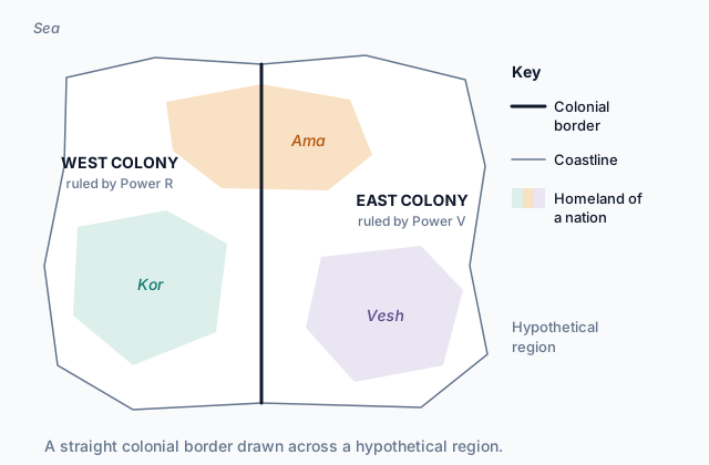
The map at the top of the page shows the result in a hypothetical region. The straight border puts the Kor and part of the Ama in West Colony, and the Vesh and the rest of the Ama in East Colony.
When colonies became independent, most kept these borders. So colonial lines still shape the map: multinational states holding nations that never chose to share a state, and nations split between states.
Quick check · Spot the error
A student explains why many former colonies are multinational states today. Which line is the first to go wrong?
2d. Independence movements and devolution
An independence movement is a campaign by a people to end rule by another state and form a sovereign state of its own. In the decades after World War II, independence movements ended most colonial empires, and dozens of new states appeared on the map, most of them inside their colonial borders.
Devolution moves power from a state's central government to its regions. It often follows national lines: a multinational state gives a region where one nation lives its own parliament, or control of its schools, language or taxes. Spain and Belgium have both handed wide powers to regional governments, among them Catalonia in Spain and Flanders in Belgium.
Devolution keeps the state whole, and sometimes it satisfies a nation's demand for self-rule. Sometimes it does not, and a region that gained power presses on toward full independence.
Independence can also follow national lines on a large scale. When the Soviet Union broke apart, its republics, each named for a nation, became independent states inside the republic borders they already had.
Quick check · Sort it
Each card describes an event in a hypothetical country. Tap a card, then the process it shows.
Devolution
Independence movement
Neither
Part 3 Watch it done Read what a colonial border left behind
Watch each step, then do the last one yourself.
In the region on the map at the top of the page, both colonies became independent and kept the colonial border. West Colony became the state of Sorra, run by the Kor, and East Colony became the state of Benn, run by the Vesh. Explain what the map implies about Sorra, Benn and the Ama today.
Predict first
Before the steps, what do you expect Sorra and Benn to be?
Step 1 · Trace where the border came from
The border is a straight line drawn by the colonial powers, and it ignores the homelands. Independence kept it, so today's border between Sorra and Benn is the colonial line.
Step 2 · Compare each state with the homelands
Sorra holds the Kor homeland and the western part of the Ama homeland. Benn holds the Vesh homeland and the eastern part. Each state holds more than one nation, so both are multinational states, a direct legacy of the colonial border.
Step 3 · Follow the Ama
The Ama homeland is split between Sorra and Benn, and neither state is run by the Ama. They are a multistate nation and a stateless nation, and self-determination gives them a claim to govern themselves.
Why this step?
Why does it matter who drew a border, when the states on both sides are now independent?
Independence changed who held sovereignty, not where the lines ran. A border drawn without regard to where peoples lived goes on dividing and joining nations long after the colonial power has gone.
Your step · Decide and justify
Finish it. The Ama in Sorra press for self-rule. Sorra's government gives the Ama region its own elected assembly, with control of schools and the use of the Ama language, while Sorra keeps the army and foreign policy. Which process is this?
Which reason supports your answer?
Part 4 Try it Trace a country's path
Hypothetical Country Lira was once a colony. Today it is an independent state, and its borders hold the homelands of the Liran and the Tem.
Try it · Put it in order
Put these events in Lira's history in the order they must have happened.
Try it · Match
Match each idea to the moment in Lira's history that shows it.
Part 5 Explain it Explain a former colony's map
Nothing you type leaves this page. Check your answer against the model and each scoring point.
Free response is 50% of the exam score. This one is shaped like Question 1, from free-response II.
Free-response practice · Question 1 style
The hypothetical state of Tamar was once a colony. The colonial power drew Tamar's borders as straight lines, and Tamar kept them when it became independent. Tamar's borders now hold the homelands of two nations, the Tama and the Hesse. The Tama run Tamar's government, and the Hesse homeland continues across the border into neighboring Country Orl.
(A) Describe what it means for Tamar to have sovereignty.
(B) Describe how Tamar's independence movement could have used the idea of self-determination.
(C) Explain how colonial boundary drawing made Tamar a multinational state.
(D) Explain one reason a newly independent state like Tamar might keep its colonial borders.
(E) Tamar's government gives the Hesse region its own elected assembly. Identify this process and describe how it differs from independence.
(F) Explain one way this process could lead to a further change in Tamar's political map.
(G) The colonial power's language is still Tamar's official language. Explain how colonialism shaped this cultural pattern.
Model answer
(A) Tamar's government has final authority over its territory: it makes and enforces the law there, and no outside power can overrule it.
(B) Its leaders could argue that the people of the colony, not a distant power, had the right to choose their own government.
(C) The colonial power drew straight lines without regard to where peoples lived, so the Tama and Hesse homelands ended up inside one colony. Tamar kept those borders, so it holds two nations.
(D) Redrawing the borders could start wars with neighbors that also claim the land, so keeping the inherited lines was safer.
(E) This is devolution: power moves from Tamar's central government to the Hesse region, but Tamar keeps its sovereignty and its borders. Independence would make the region a separate sovereign state.
(F) Having their own assembly could strengthen the Hesse demand for self-determination, so they press for independence, which would add a new border to Tamar's map.
(G) The colonial power ran government, courts and schools in its own language. Educated people learned it, and after independence it stayed as a shared language between the Tama and the Hesse, so it remained the official language.
Score your own answer. This is a self-check, not a grade. Tick each point your answer makes.
Part 6 Check yourself The regions of Country Ostra
The case questions use the table. The others mix the ideas from the whole lesson.
Hypothetical Country Ostra became independent from colonial rule and kept its colonial borders, which were drawn as straight survey lines. The table shows its three regions today.
| Region | Main nation | Regional government | Recent events |
|---|---|---|---|
| Central | Ostrans | None; ruled directly by the national government | Ostrans run the national government |
| Ket | Ket | Elected assembly that runs schools and police | After protests, the national government gave the assembly control of some taxes |
| Vali | Vali | Elected assembly that runs schools | The Vali homeland continues across the border into Country Pemba; a Vali party calls for a vote on independence |
Case question 1 · Multiple choice
Which concept does the Ket region's situation illustrate?
Case question 2 · Multiple choice
Suppose the Vali vote for independence and win it. Which change to the political map is most likely?
Case question 3 · Select all
Which two conclusions does the case support? Select two.
Select 2 answers, then check.
The rest stand on their own and do not use the case.
Check yourself · Fill the statement
Three moments from the history of the hypothetical Country Varn.
For decades before Varn became a colony, a distant power controlled the trade of its ports without governing the land, an example of . When the colony of Varn later demanded to choose its own government instead of being ruled from overseas, its leaders appealed to . Years after independence, a region of Varn asked to leave, and Varn's government refused, defending its .
Check yourself · Rank it
These three hypothetical places all began as regions of Country Quin. Rank them by how much they govern themselves today.
Most self-government first
Give each one a place, 1 for first. Give two the same place if they are equal.
Your ranking: none yet
Part 7 Keep it Bring back earlier ideas
This lesson builds on the political entities of Topic 4.1; the second question brings back the diffusion of religions from Topic 3.7.
Bring it back · Multiple choice
In hypothetical Country Sulo, the Deni people elect a council that runs schools and land use in the Deni District, while Sulo's national government keeps the army and foreign policy. Which term describes the Deni District?
Bring it back · Sort it
Each card describes a hypothetical religion. Tap a card, then the kind of religion it describes.
Universalizing religion
Ethnic religion
In three lines
- Sovereignty is a state's final authority over its territory; self-determination is a people's claim to choose its own government.
- Colonial powers drew many borders without regard to where peoples lived, and most new states kept them.
- Independence movements create new states; devolution moves power to regions inside a state and can lead on to independence.
Exam strategy for this topic
- Section I, Multiple Choice: 60 questions in 60 minutes.
- Section II, Free Response: 3 questions in 75 minutes.
When a question describes a change to a country, ask who holds the final say before and after it. If the state still does, the change is devolution or self-rule; if a new state holds it, the change is independence.
Questions students ask
What is the difference between colonialism and imperialism?
Imperialism is the wider idea: one state extending its power over other peoples and lands, by conquest, trade or direct rule. Colonialism is one form of it, in which a state takes and governs a territory as a colony, often sending settlers and officials.
Does devolution always lead to independence?
No. Devolution can satisfy a nation's demand for self-rule and hold a state together, or it can be a step toward independence. Which happens depends on the case.
Why did so many new states keep their colonial borders?
Redrawing every border at once risked wars between neighbors, and new governments wanted to keep the territory and resources they had inherited. Many newly independent states agreed to respect the borders they started with.
Does self-determination mean a right to a new state?
Not always. A people may use it to win independence, to gain self-rule inside a state, or to choose to stay as they are. States often answer with their sovereignty, and the two ideas pull against each other.
Are the places in this lesson real?
The countries, colonies, nations and regions in the map, the scenarios and the questions are hypothetical. The Berlin Conference, Spain, Belgium, the Soviet Union and the United Nations, named in the teaching, are real.
Course alignment, for teachers
AP Human Geography topic 4.2, Unit 4: Political Patterns and Processes.
- Skill 3.E: Explain what maps or data imply or illustrate about geographic principles, processes, and outcomes.
This lesson maps all 2 essential knowledge statements of the topic to the part that teaches each one: 2 are checked by a scored question. The map is in the lesson file.