Unit 4 · Topic 4.4 · about 30 minutes · 7 parts · 14 scored checks, 3 of them multiple choice
AP Human Geography 4.4: Defining Political Boundaries
Unit 4: 12 to 17% of the multiple-choice section
What you'll be able to do
- Define the types of political boundaries geographers use (relict, superimposed, subsequent, antecedent, geometric and consequent) and name the types a real or hypothetical boundary fits from its history, its line on the map and whether it still divides states.
Key vocabulary
| Term | What it means | The exam trap |
|---|---|---|
| Antecedent boundary | A boundary drawn before the area it divides was settled by the people who live there now. | Ask when the line was drawn compared with when people settled. |
| Subsequent boundary | A boundary drawn after the area was settled, as its cultural landscape took shape. | Consequent boundaries are also subsequent, so name the more exact type as well when the evidence shows it. |
| Consequent boundary | A boundary drawn to fit cultural differences already present, such as language, religion or ethnicity. | Check the line against a map of the cultures, not only a map of the states. |
| Superimposed boundary | A boundary placed over an area by an outside power, with little regard for the cultures already there. | Ask who drew the line, and from where. |
| Geometric boundary | A boundary drawn as a straight line or an arc, often along a line of latitude or longitude, without regard to physical or cultural features. | Read the line's shape on the map before you read its history. |
| Relict boundary | A former boundary that no longer divides states but can still be seen in the cultural landscape. | Ask whether the line still works as a boundary today. |
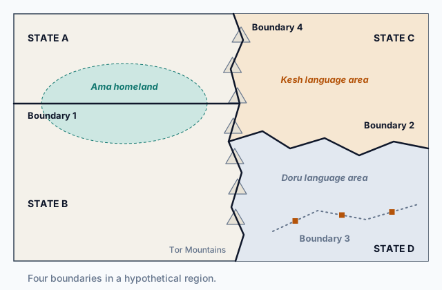 Tap to open the picture full size
Part 1 Think first A line drawn on empty land
Commit to a guess first. Being wrong now makes the right idea stick better.
Predict first
Surveyors mark a boundary between two hypothetical countries straight across an empty grassland where no one lives yet. Over the next hundred years, farmers settle the grassland on both sides of it. How will the boundary most likely relate to the people living near it then?
In short. Geographers name a political boundary by when it was drawn compared with settlement, by whether it follows or ignores the cultures it crosses, by its shape, and by whether it still divides states.
- An antecedent boundary was drawn before the area was settled; a subsequent boundary was drawn after, and a consequent boundary is a subsequent one drawn to follow cultural differences such as language or religion.
- A superimposed boundary was placed over an area by an outside power, such as a colonial government, with little regard for the peoples already there; a geometric boundary is a straight line or an arc.
- A relict boundary no longer divides states but can still be seen in the cultural landscape, and one boundary can fit more than one type.
Part 2 Learn it Six types of political boundaries
2a. Before or after settlement: antecedent and subsequent
Geographers sort political boundaries by how and when they were drawn. The first question is timing: was the line drawn before or after people settled the land it divides?
An antecedent boundary was drawn before the area was settled by the people who live there now. Surveyors drew it across empty or nearly empty land, often forest, desert, mountains or open grassland, and settlers later filled in on each side. Because it came first, it did not cut through anyone's community; settlement grew up around it.
A subsequent boundary was drawn after people had settled the area, while its cultural landscape of towns, farms, languages and religions was already taking shape. It might be set by a treaty after a war, or agreed by two states over land that both already used. Because people were there first, the line has to deal with them: it can follow the differences between them or cut across them.
The words help: antecedent means going before, and subsequent means coming after.
Quick check · Sort it
Each card describes a boundary in a hypothetical place. Tap a card, then the type that fits its timing.
Antecedent
Subsequent
2b. Following culture or ignoring it: consequent and superimposed
Once people live in an area, a boundary drawn there can treat their cultures in two very different ways.
A consequent boundary is drawn to fit cultural differences that are already there: it follows the line where one language, religion or ethnic group gives way to another. Because each group ends up mostly on its own side, a consequent boundary can ease tension between them. It is drawn after settlement, so every consequent boundary is also a kind of subsequent boundary, the kind that follows culture.
A superimposed boundary is placed over an area by an outside power, such as a colonial government, with little or no regard for the cultures already there. It can split one people between two states, or force rival peoples into one. Colonial powers drew many such lines, in Africa and elsewhere, often in distant capitals by officials who had never seen the land. Many of those lines outlasted colonial rule, and some of today's disputes within and between states trace back to them.
To tell the two apart, ask who drew the line and whether it follows the cultures on the ground.
Quick check · Sort it
Each card describes a boundary drawn through a settled, hypothetical region. Tap a card, then its type.
Consequent
Superimposed
2c. Shape and history: geometric and relict
Two more types describe what a boundary looks like and whether it still works.
A geometric boundary is a straight line or an arc, often following a line of latitude or longitude, drawn without regard to the rivers, mountains or peoples it crosses. Geometric boundaries are common where lines were drawn on a map far away, over land the mapmakers had not walked, or over land with few people. On a map you can spot one by its ruler-straight edges.
A relict boundary no longer works as a political boundary, yet it can still be seen in the cultural landscape. Two states merge, or a border moves, and the old line stops dividing anything. But traces stay behind: the ruins of a wall or of guard posts, a change in house styles, field shapes or road patterns where the line used to run, even a difference in dialect from one side to the other. Geographers read a relict boundary as part of an area's sequent occupance, the marks each group that held the land left behind.
Being old does not make a boundary relict. Many very old boundaries still divide states today.
Quick check · Fill the statement
Complete the description of two boundaries in hypothetical Country Taro.
Taro's northern boundary runs for 600 km along a single line of latitude, crossing rivers and hills without bending, which makes it . Inside Taro, a row of crumbling watchtowers marks where two kingdoms met before they united; that line divides no states today, which makes it .
2d. One line, several types
The types answer different questions, so one boundary can fit more than one.
- When was it drawn? Antecedent, before settlement, or subsequent, after.
- How does it treat the cultures there? Consequent if it follows them; superimposed if outsiders imposed it without regard to them.
- What shape is it? Geometric if it is a straight line or an arc.
- Does it still work? Relict if it no longer divides states but can still be seen.
A colonial power that drew a straight line along a parallel through land where one people already lived made a boundary that is both geometric and superimposed. A straight line surveyed across an empty desert before anyone settled there is both geometric and antecedent. Every consequent boundary is also subsequent. And when a superimposed boundary is later erased but its old customs posts still stand, it has become relict.
One pair cannot go together: a line cannot be drawn both before and after settlement, so it is never both antecedent and subsequent. A superimposed line usually ignores the cultural divides already there, so it is rarely consequent as well. Watch it done works through a boundary on the map at the top of the page that fits two types.
Quick check · Select all
Officials of a foreign empire drew a boundary along a single line of longitude, straight through the farmland of the hypothetical Hesu people, who had lived there for centuries. The line still divides two states today. Which two types describe it? Select two.
Select 2 answers, then check.
Part 3 Watch it done Name the boundaries on the map
Watch each step, then do the last one yourself.
The map at the top of the page shows four boundaries in a hypothetical region. Here is how each was drawn.
- Boundary 1: officials of a foreign empire drew it in their own capital as a straight east-west line, after the Ama people had long lived on both sides of where it runs.
- Boundary 2: the governments of States C and D drew it after a vote, along the line where Kesh-speaking villages give way to Doru-speaking villages.
- Boundary 3: it was the line between two kingdoms that united into State D a century ago. It divides no states now, but the ruins of a wall still mark it.
- Boundary 4: surveyors marked it along the crest of the Tor Mountains when no one lived there; villages grew up in the valleys on each side later.
Name the type of each boundary.
Step 1 · Boundary 1: its shape
It is a straight east-west line, drawn without regard to the land or the people it crosses. That makes it geometric.
Step 2 · Boundary 1: who drew it, and over whom
Outsiders drew it far away, over land where the Ama already lived, and it splits the Ama homeland between States A and B. That makes it superimposed. So Boundary 1 is both geometric and superimposed.
Why this step?
Why can Boundary 1 be two types at once?
The types answer different questions. Geometric describes the line's shape; superimposed describes who drew it and how it treats the people there. One line has both a shape and a history, so it can carry one type for each.
Your step · Sort it
Finish it. Tap each of the other three boundaries, then the type its history and the map show.
Antecedent
Consequent
Superimposed
Relict
Part 4 Try it Boundaries in new places
Try it · Put it in order
One boundary in a hypothetical region changes over two centuries. Put the stages in the order they happened.
Try it · Decide and justify
Two hypothetical peoples share one region: the Nara live mostly in the hills and the Vos mostly on the plain. A peace agreement creates two states, and the negotiators can draw either a straight line along a parallel, which is easy to survey, or a winding line along the foot of the hills, where Nara villages give way to Vos villages. Which line is less likely to split either people between the two states?
Which reason supports your answer?
Part 5 Explain it Explain the boundaries of Lund and Paro
Nothing you type leaves this page. Check your answer against the model and each scoring point.
Free response is 50% of the exam score. This one is shaped like Question 1, from free-response II.
Free-response practice · Question 1 style
Hypothetical Country Lund and Country Paro share a boundary that a colonial power drew a century ago. The colonial mapmakers drew it as a straight line along a parallel, through the homeland of the Sabe people, who had lived there for many generations. Farther east, an older line between two kingdoms that later united no longer divides any states.
(A) Identify the type of boundary that is drawn as a straight line along a parallel.
(B) Describe what makes the boundary between Lund and Paro a superimposed boundary.
(C) Explain one way the superimposed boundary could cause problems for the Sabe people.
(D) Describe the difference between an antecedent boundary and a subsequent boundary.
(E) Explain why a consequent boundary is less likely than a superimposed boundary to split an ethnic group between states.
(F) Identify the type of boundary formed by the old line between the two kingdoms that united.
(G) Describe one feature of the cultural landscape that could show where the old line between the two kingdoms ran.
Model answer
(A) A geometric boundary.
(B) An outside power, the colonial government, drew it, and it drew the line through the Sabe homeland without regard to the people who already lived there.
(C) The Sabe are split between two states, so families and villages can be separated by border controls, and in each state the Sabe are a minority with less say in a government run by other groups. That can lead them to demand their own state or to join their kin across the border, a cause of conflict.
(D) An antecedent boundary is drawn before the area is settled by the people who live there now, so settlement grows up around it. A subsequent boundary is drawn after the area is settled, so it has to deal with the people and cultures already there.
(E) A consequent boundary is drawn to follow existing cultural differences, such as where one ethnic group's villages give way to another's, so each group ends up mostly on one side. A superimposed boundary is drawn by outsiders who ignore where groups live, so it can cut straight through one.
(F) A relict boundary.
(G) A row of ruined guard posts may still stand along the old line, where each kingdom once watched the other.
Score your own answer. This is a self-check, not a grade. Tick each point your answer makes.
Part 6 Check yourself The boundaries around Lake Orra
The case questions use the table. The others mix the ideas from the whole lesson.
A geographer studying the hypothetical Lake Orra region recorded four boundaries, P, Q, R and S.
| Boundary | Who drew it, and when | Its line | Today |
|---|---|---|---|
| P | A colonial government, after the Fen people had long lived there | Straight, along a line of longitude | Divides two states |
| Q | Two neighboring states, by agreement, after the area was settled | Winds along the edge between Tal-speaking and Mor-speaking towns | Divides two states |
| R | Two kingdoms, centuries ago | Followed a river | Divides no states; the kingdoms merged, but a line of old forts remains |
| S | Surveyors, before anyone settled the area | Follows a desert ridge | Divides two states |
Case question 1 · Multiple choice
Which statement about Boundary P is best supported by the table?
Case question 2 · Fill the statement
Use the table to complete the description of two more boundaries.
Boundary Q is , and Boundary S is .
Case question 3 · Multiple choice
Why is Boundary R a relict boundary?
The rest stand on their own and do not use the case.
Check yourself · Spot the error
A student names the type of hypothetical Boundary T. Which line is the first to go wrong?
Check yourself · Sort it
Each card describes a line in a hypothetical place. Tap a card, then whether it is geometric, relict or neither.
Geometric
Relict
Neither
Part 7 Keep it Bring back earlier ideas
This lesson stands on political power from Topic 4.3 and the types of political entities from Topic 4.1.
Bring it back · Multiple choice
Hypothetical Country Ilo is small, but its islands lie on both sides of the only channel between two busy seas. Which term describes the channel, and what power does it give Ilo?
Bring it back · Match
Match each type of political entity to the hypothetical description that fits it.
In three lines
- Antecedent boundaries were drawn before settlement and subsequent ones after; a consequent boundary is a subsequent one that follows cultural differences.
- A superimposed boundary was imposed by an outside power, a geometric one is a straight line or an arc, and a relict one no longer divides states but still shows.
- The types answer different questions, so one boundary can fit more than one, such as geometric and superimposed.
Exam strategy for this topic
- Section I, Multiple Choice: 60 questions in 60 minutes.
- Section II, Free Response: 3 questions in 75 minutes.
When a question asks you to name a boundary type, read for the clues: when the line was drawn compared with settlement, who drew it and whether it follows the cultures there, its shape, and whether it still divides states. Name every type the clues support, and say which clue supports each.
Questions students ask
Can a boundary be more than one type?
Yes. The types answer different questions, so a colonial line drawn straight along a parallel through settled land is both geometric and superimposed, and every consequent boundary is also subsequent.
What is the difference between subsequent and consequent?
A subsequent boundary is any boundary drawn after the area was settled. A consequent boundary is the kind of subsequent boundary that is drawn to follow cultural differences, such as language or religion.
Where does a boundary along a river or a mountain range fit?
A line that follows a river or a ridge is often called a physical or natural boundary. It can still be antecedent, subsequent or consequent, depending on when and why it was drawn, and it can turn relict if it stops dividing states.
Why do superimposed boundaries still matter?
Many outlasted the colonial governments that drew them, so peoples split or forced together by those lines still live with them. Some of today's disputes within and between states trace back to them.
Are the places in this lesson real?
No. Every country, region, people and boundary here is hypothetical, made up to show each type clearly. Real boundaries often fit more than one type, and their histories are messier.
Course alignment, for teachers
AP Human Geography topic 4.4, Unit 4: Political Patterns and Processes.
- Skill 1.D: Describe a relevant geographic concept, process, model, or theory in a specified context.
This lesson maps the one essential knowledge statement of the topic to the part that teaches each one: 1 is checked by a scored question. The map is in the lesson file.