Unit 4 · Topic 4.5 · about 30 minutes · 7 parts · 14 scored checks, 3 of them multiple choice
AP Human Geography 4.5: The Function of Political Boundaries
Unit 4: 12 to 17% of the multiple-choice section
What you'll be able to do
- Explain the nature and function of international boundaries: how a boundary is made and why it is contested, whether it follows a cultural divide or was set by policy or a demilitarized zone, how land and sea boundaries shape identity, interaction and disputes over resources, and how UNCLOS divides the sea into zones.
Key vocabulary
| Term | What it means | The exam trap |
|---|---|---|
| Define (a boundary) | To describe a boundary's line in words, in a treaty or other legal document. | Do not confuse the words of a treaty with the line on a map or on the ground. |
| Delimit | To draw a defined boundary on official maps. | Delimiting happens on paper or screen, not on the ground. |
| Demarcate | To mark a boundary on the ground with posts, markers, fences or walls. | Do not confuse it with delimit; demarcation is the step you can see on the landscape. |
| Administer (a boundary) | To run a boundary day to day: staffing crossings, checking people and goods, and keeping markers in place. | Do not confuse running a border with drawing or marking it. |
| Demilitarized zone | A strip of land that, under a ceasefire or treaty, no army may enter. | Do not confuse it with other kinds of buffer between rivals. |
| Baseline | The line along a coast, usually the low-water line, from which every sea zone is measured. | It is a line on the coast, not a band of sea. |
| Territorial sea | The band of sea from a coastal state's baseline out to 12 nautical miles, where the state is sovereign. | Measure from the baseline, not from the edge of another zone. |
| Exclusive economic zone | The band of sea out to 200 nautical miles from a coastal state's baseline, whose fish, oil, gas and minerals are under that state's control. | Read what a question says a ship is doing there before you say what the coastal state may do. |
| International waters | The sea beyond every state's exclusive economic zone, also called the high seas, which no state owns. | They begin past 200 nautical miles from every coast, not just past one country's territorial sea. |
 Tap to open the picture full size
Part 1 Think first One treaty, two claims
Commit to a guess first. Being wrong now makes the right idea stick better.
Predict first
Two hypothetical neighboring countries, Arlen and Bosk, signed a treaty saying their border follows "the crest of the Tell Hills." Decades later, both countries claim a valley village at the edge of the hills, and each one points to the same treaty. What is the most likely explanation?
In short. Political boundaries mark the limits of a state's sovereignty: they are defined, delimited, demarcated and administered, they often follow cultural, national or economic divisions but are sometimes set by outside policy or a demilitarized zone, and at sea UNCLOS divides the water into territorial seas, exclusive economic zones and international waters.
- A boundary is defined in a treaty's words, delimited on a map, demarcated on the ground and administered by the states on each side, and it can be contested at any step.
- Many boundaries coincide with cultural, national or economic divisions; others, such as many drawn in Africa after the Berlin Conference, were set by outside powers, and some began as demilitarized zones.
- Under UNCLOS a coastal state is sovereign out to 12 nautical miles and controls the resources out to 200 nautical miles; beyond that lie international waters open to every state.
Part 2 Learn it What boundaries do and how they are made
2a. Four steps in making a boundary
A political boundary marks where one state's sovereignty ends and the next one's begins. Making one takes four steps.
- Define: a treaty or other legal document describes the line in words, such as "along the main channel of the river."
- Delimit: mapmakers draw that line on official maps, often with exact coordinates.
- Demarcate: crews mark the line on the ground with posts, markers, fences or walls.
- Administer: the states on each side run the border over time, staffing crossings, checking people and goods, and keeping the markers in place.
Not every boundary goes through every step. Many lines across deserts or high mountains are delimited on maps but never demarcated, and a quiet border may have few crossing posts.
Boundaries are often contested. Neighbors can argue over what a treaty's words mean, over where the line sits when a river shifts its channel, or over the land and resources on one side. Arlen and Bosk's quarrel is the first kind: "the crest of the Tell Hills" can be read more than one way.
Quick check · Put it in order
Hypothetical Countries Kael and Dorn are setting up a new border. Put these events in the order the four steps of boundary making take, first to last.
2b. What a boundary follows
Many boundaries coincide with divisions that existed before the line. A border may separate two nations with their own languages and histories, follow a change in religion, or mark a sharp economic divide, such as a change in currency, trade rules and wages.
Other boundaries were created by policy, with little regard for the people living there. In the 1880s, European powers met at the Berlin Conference and set rules for claiming territory in Africa. The colonial borders drawn in the years that followed divided land among those powers, and many cut across ethnic and cultural groups, splitting some peoples between two colonies and placing rival groups in one. Many of those lines became the borders of independent states.
Some boundaries begin as a demilitarized zone, a strip of land that, under a ceasefire or treaty, no army may enter. A demilitarized zone between two hostile states can harden into the working border between them, even with no final peace.
The question to ask of any boundary: did it follow a division that was already there, or was it laid down by policy or a ceasefire?
Quick check · Sort it
Each card describes how a hypothetical border came about. Tap a card, then the kind of boundary it is.
Coincides with a cultural, national or economic divide
Created by outside powers' policy
Created by a demilitarized zone
2c. Boundaries shape identity and interaction
A boundary does more than mark sovereignty. It changes how people on each side see themselves and how much they deal with one another.
Identity. Passports, flags at crossings, school maps and a border guard's questions all remind people which state they belong to. Over time a line can build a separate national identity on each side, even between people who once shared one. A line that splits a group, as many colonial borders did, can also keep that group's sense of a shared homeland alive across it.
Interaction. A border with checks, fees and fences discourages trade, commuting and visits. International agreements can lower those barriers: a trade deal removes tariffs, and some agreements let people cross with no passport checks. Border towns then trade, work and shop across the line, and a regional identity can grow that spans it. A boundary shapes ties inside a country too: a region cut off from the rest of its state by a border or a sea may trade more with the neighbor next door than with its own capital.
Resources. Rivers, lakes, aquifers, oil fields and fish do not stop at boundaries. A line across a shared resource can start a dispute when one side takes more than before, or lead to cooperation when the states agree to share it. At sea the same thing happens with fish, oil and gas, which is why the sea has its own boundary rules.
Quick check · Select all
Hypothetical Countries Pell and Rua sign an agreement that ends passport checks and tariffs at their shared land border. Which two effects are most likely over the following years? Select two.
Select 2 answers, then check.
2d. Boundaries at sea: UNCLOS
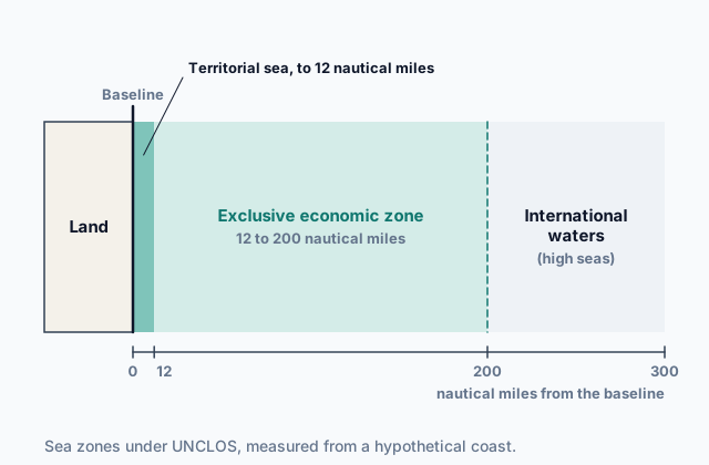
The United Nations Convention on the Law of the Sea (UNCLOS) sets out the rights and responsibilities of states in using the oceans. Every zone is measured from a coastal state's baseline, usually the low-water line along its shore.
- The territorial sea reaches 12 nautical miles from the baseline. The coastal state is sovereign there, much as on its land, though foreign ships may pass through peacefully.
- The exclusive economic zone (EEZ) reaches 200 nautical miles from the baseline. The coastal state alone controls the fish, oil, gas and minerals there and decides who may take them, but every country's ships and planes may travel through it.
- Beyond the exclusive economic zones lie international waters, often called the high seas, which no state owns and every state may use.
In return for its rights, the coastal state must let foreign ships pass peacefully through its territorial sea and travel freely through its exclusive economic zone, and must look after the fish there so they are not used up.
Where two coasts are less than 400 nautical miles apart, their 200-mile zones overlap, and the two states must agree on a line between them, often one halfway between the coasts. Overlapping zones, and islands that stretch a state's zones far from its mainland, are common causes of disputes over fish, oil and gas. The picture at the top of the page shows the zones off one coast.
Quick check · Match
Match each term from UNCLOS to its description.
Part 3 Watch it done Where two sea zones meet
Watch each step, then do the last one yourself.
Hypothetical Countries Tarn and Vell face each other across a sea, and their coasts are 320 nautical miles apart. Each claims the full exclusive economic zone UNCLOS allows. Along the straight line between the two coasts, how wide is the band of sea that lies inside both zones?
Predict first
Before the steps, do the two zones overlap at all?
Step 1 · Measure each zone from its own coast
Each exclusive economic zone reaches 200 nautical miles from its own country's baseline. Put both zones on one ruler that starts at Tarn's coast (0) and ends at Vell's coast (320).
Step 2 · Find where Vell's zone begins
Vell's zone runs 200 nautical miles out from Vell, so it reaches back toward Tarn as far as 320 minus 200, which is 120 nautical miles from Tarn's coast.
Why this step?
Why measure Vell's zone from Tarn's coast instead of from Vell's?
Two claims can only be compared on one ruler. Once both zones are measured from the same coast, you can see where one ends, where the other starts, and whether they cover the same water.
Your step · Calculate
Finish it. Measured from Tarn's coast, Vell's zone begins 120 nautical miles out. How many nautical miles wide is the band that both countries can claim?
nautical miles
Part 4 Try it Rules at sea and on land
Try it · Rank it
Hypothetical Country Osk's coast faces open ocean, with no other country's coast within 400 nautical miles. Four foreign fishing boats are fishing at these distances from Osk's baseline. Rank the boats by how much of Osk's law applies to each one.
Most of Osk's law first
Give each one a place, 1 for first. Give two the same place if they are equal.
Your ranking: none yet
Try it · Decide and justify
Hypothetical Countries Hollin and Maro share a border that runs across a large aquifer, an underground layer of water that wells on both sides draw from. Hollin's farmers start pumping far more water than before, and the water in Maro's wells begins to drop. What is more likely to follow between the two countries?
Which reason supports your answer?
Part 5 Explain it Explain a country's land and sea boundaries
Nothing you type leaves this page. Check your answer against the model and each scoring point.
Free response is 50% of the exam score. This one is shaped like Question 1, from free-response II.
Free-response practice · Question 1 style
Hypothetical Country Selk has a long coastline and a land border with hypothetical Country Tov. A colonial power drew the land border long ago, and it splits the homeland of the Ama people between the two countries. Selk has found natural gas under the seabed 120 nautical miles off its coast, and no other country's coast lies within 400 nautical miles of that part of Selk's shore.
(A) Identify the step of boundary making in which a border is marked on the ground with posts, markers or fences.
(B) Describe one way the border between Selk and Tov differs from a boundary that coincides with a cultural division.
(C) Explain one way the land border could affect the identity of the Ama people.
(D) Identify the zone under UNCLOS in which Selk's gas field lies, and describe one right Selk has there.
(E) Explain why a cargo ship from Tov may sail through that zone without Selk's permission.
(F) Explain the degree to which UNCLOS prevents disputes between countries over resources at sea.
(G) Ama families live on both sides of the land border. Explain one way strict border controls could change how Ama people move between the two countries.
Model answer
(A) Demarcation.
(B) A boundary that coincides with a cultural division follows a line where language, religion or nationality already changes. The border between Selk and Tov was drawn by a colonial power without regard to the Ama, so it cuts across one cultural group instead of following a divide between groups.
(C) The border puts Ama on each side under a different government, with different schools, passports and flags. Over generations, Ama in Selk and Ama in Tov may come to identify more with their own state, weakening the shared Ama identity.
(D) The exclusive economic zone, which reaches 200 nautical miles from the baseline. Selk alone has the right to drill for the gas and sell it.
(E) Selk's rights in the exclusive economic zone cover its resources, such as fish, oil and gas, not travel. UNCLOS keeps the zone open to every country's ships, so a ship that is only passing through needs no permission.
(F) UNCLOS prevents many disputes by giving every coastal state the same fixed distances, 12 and 200 nautical miles, so most states know which waters' resources are theirs. It does not prevent them all: where coasts are less than 400 nautical miles apart the zones overlap and the states must agree on a line, and claims to small islands can stretch zones, so disputes over fish, oil and gas still arise.
(G) Strict controls act as an obstacle to movement: crossing takes more time, papers and money, so Ama families visit, trade and attend family events across the line less often. Some families may move to one side for good to stay together.
Score your own answer. This is a self-check, not a grade. Tick each point your answer makes.
Part 6 Check yourself The sea between Corva and Brenn
The case questions use the table. The others mix the ideas from the whole lesson.
Hypothetical Corva, an island state, and hypothetical Brenn, on the mainland, face each other across a sea. Their coasts are 260 nautical miles apart. A survey lists six features in or under the sea, with each one's distance from both coasts. All but the seamount lie on the straight line between the two coasts; the seamount lies off Corva's far side, facing the open ocean, where no other country's coast is near.
| Feature | From Corva's coast | From Brenn's coast |
|---|---|---|
| Coral reef | 9 | 251 |
| Shipping lane crossing | 40 | 220 |
| Gas field | 150 | 110 |
| Fish bank | 195 | 65 |
| Mineral bed on the seafloor | 215 | 45 |
| Seamount | 240 | More than 500 |
Case question 1 · Multiple choice
A fishing fleet from Brenn starts fishing at the coral reef in the table. Which statement best describes Corva's rights at the reef?
Case question 2 · Sort it
Using the table, sort each feature except the coral reef by which country's 200-nautical-mile zone it lies in. Tap a card, then the right box.
Corva's zone only
Brenn's zone only
Both countries' zones
Neither country's zone
Case question 3 · Multiple choice
Corva and Brenn both claim the gas field. They sign an agreement that draws their sea boundary halfway between the coasts and sets up a joint company to drill the field and split the revenue. Which outcome is most likely?
The rest stand on their own and do not use the case.
Check yourself · Spot the error
A student describes how the border between hypothetical Countries Fen and Gall came to be. Which line is the first to go wrong?
Check yourself · Fill the statement
Complete the description of two ways boundaries are created.
After the Berlin Conference, many borders in Africa were drawn to divide land among , so they often cut across instead of following them. When a war ends in a ceasefire, a strip of land that neither army may enter, called a , can become the working border.
Part 7 Keep it Bring back earlier ideas
This lesson stands on the types of boundaries from Topic 4.4 and the political processes of Topic 4.2.
Bring it back · Multiple choice
Two hypothetical neighboring countries agree that their border will follow a line of latitude across a plain where farming villages have stood for centuries. Which type of boundary is this?
Bring it back · Fill the statement
Two ideas about how states change.
When a national group inside a state wins the power to run its own region's schools and taxes, that transfer of power from the central government is . The group's claim that a people should choose how it is governed rests on the principle of .
In three lines
- Boundaries are defined in words, delimited on maps, demarcated on the ground and administered, and they can be contested at every step.
- Some follow cultural, national or economic divides; others were set by outside policy, such as after the Berlin Conference, or by a demilitarized zone.
- UNCLOS: sovereignty to 12 nautical miles, resource rights to 200, international waters beyond; where zones overlap, states must agree on a line.
Exam strategy for this topic
- Section I, Multiple Choice: 60 questions in 60 minutes.
- Section II, Free Response: 3 questions in 75 minutes.
When a question names a step in making a boundary, ask where the line is: in words (defined), on a map (delimited), on the ground (demarcated) or in daily use (administered). For the sea, name the zone a place lies in before you say what a state may do there.
Questions students ask
Is a nautical mile the same as a mile?
No. A nautical mile is a little longer than a land mile, about 1.85 kilometers. UNCLOS measures every zone in nautical miles.
Does every boundary go through all four steps?
No. Many boundaries across deserts, mountains or the sea are defined and delimited but never demarcated, and some quiet borders are barely administered. The steps describe how a boundary can become fully established, not a rule every border follows.
What happens when two countries' exclusive economic zones overlap?
Where two coasts are less than 400 nautical miles apart, the 200-mile zones cover some of the same water. UNCLOS leaves the two states to agree on a line, often one halfway between the coasts, or to share the resources. Until they agree, the overlap can be the scene of a dispute.
Did the Berlin Conference draw Africa's borders?
It set the rules European powers used to claim African territory. Most of the borders themselves were drawn in agreements among those powers in the years that followed, and many cut across ethnic and cultural groups and later became the borders of independent states.
Are the countries in this lesson real?
No. Every country, people and place in the examples and questions is hypothetical, chosen to show each idea clearly. The Berlin Conference and UNCLOS are real, and the lesson states only basic facts about them.
Course alignment, for teachers
AP Human Geography topic 4.5, Unit 4: Political Patterns and Processes.
- Skill 5.D: Explain the degree to which a geographic concept, process, model, or theory effectively explains geographic effects across various geographic scales.
This lesson maps all 4 essential knowledge statements of the topic to the part that teaches each one: 4 are checked by a scored question. The map is in the lesson file.