Unit 4 · Topic 4.6 · about 30 minutes · 7 parts · 14 scored checks, 3 of them multiple choice
AP Human Geography 4.6: Internal Boundaries
Unit 4: 12 to 17% of the multiple-choice section
What you'll be able to do
- Explain the nature and function of internal boundaries: how voting districts, redistricting and gerrymandering affect election results at various scales, and identify the scale a map or an election result shows.
Key vocabulary
| Term | What it means | The exam trap |
|---|---|---|
| Voting district | An area whose voters together elect their own representative. | A district line is an internal boundary that organizes elections; it does not mark a limit of sovereignty. |
| Census | An official count of a country's population, often taken every ten years. | A census counts people, not voters for each party. |
| Redistricting | Redrawing the lines of voting districts, usually after a census, so each district holds about the same number of people. | Redrawing lines is not by itself gerrymandering; ask what the new lines were drawn to do. |
| Gerrymandering | Drawing district lines on purpose to give one party or group an advantage. | Look at who drew the map and how it groups each party's voters before you use the term. |
| Packing | Crowding a rival party's voters into a few districts that it wins by huge margins. | Name the party being packed; the move works against that party. |
| Cracking | Splitting a rival party's voters across many districts so they fall short of a majority in each. | Name the party being cracked; the move works against that party. |
| Scale of analysis | The extent of the area a map or data set covers, from local to national to global. | Do not confuse it with map scale, the ratio of a distance on a map to the distance on the ground. |
 Tap to open the picture full size
Part 1 Think first How many seats can 40 percent win?
Commit to a guess first. Being wrong now makes the right idea stick better.
Predict first
The hypothetical state of Varna elects five members of its country's legislature, one from each of five districts with equal numbers of voters. In the last election, 60 percent of Varna's voters chose Party A and 40 percent chose Party B. Each seat goes to the party with the most votes in that district. With the right district lines, what is the largest number of the five seats Party B could win?
In short. Voting districts are internal boundaries that divide a place into areas that each elect a representative; redrawing them is redistricting, and drawing them to favor one party or group is gerrymandering, which can change who wins at the scale of a city, a state or a whole country.
- After a census, district lines are redrawn so that each district holds about the same number of people.
- A gerrymander packs a rival party's voters into a few districts it wins by huge margins, or cracks them across many districts it narrowly loses.
- The same votes can give very different seat counts under different maps, and the maps of several states together can tip a national legislature.
Part 2 Learn it Lines drawn inside a state
2a. Voting districts and redistricting
Many countries elect their legislatures by voting district: the land is divided into areas, and the voters in each one elect their own representative. District lines are internal boundaries, like the lines between states or provinces, but they exist to organize elections.
Districts are meant to hold about the same number of people, so that each vote counts about the same. People move, are born and die, so the lines go out of date. A country that counts its people in a regular census, often once every ten years, can then give more seats to the states or regions that grew and fewer to those that shrank. Within each one, the lines are redrawn so the districts are equal again. Redrawing district lines is redistricting.
A new map is not neutral just because its districts are equal in size. There are countless ways to cut a state into five equal districts, and each one groups the voters differently. Who draws the lines, and with what goal, can decide who wins.
Quick check · Put it in order
Hypothetical Country Mora elects its national legislature by district. Put these events in order, first to last.
2b. Gerrymandering: packing and cracking
Gerrymandering is drawing district lines to give one party or group an advantage. Mapmakers who know where each party's voters live use two moves.
Packing crowds a rival's voters into a few districts. The rival wins those by huge margins, and every vote past a bare majority does nothing for it.
Cracking splits a rival's voters across many districts, so they fall a little short of a majority in each, and the rival wins few seats or none.
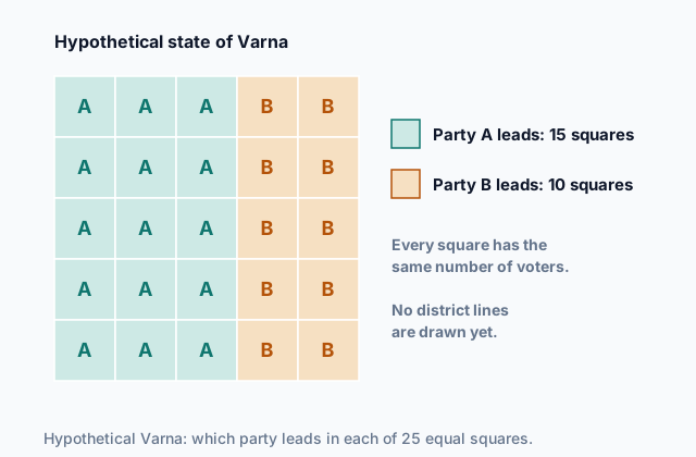
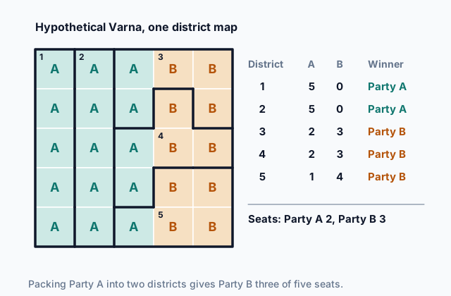
The map at the top of the page shows hypothetical Varna, 25 squares of equal population. Party A leads in 15 and Party B in 10. Cut Varna into its five rows, and every district has 3 A squares and 2 B squares, so Party A wins all five seats: Party B has been cracked. The map below does the opposite. It packs Party A into two districts it wins with every square, then draws the other three so Party B leads each of them.
 Tap to open the picture full size
Same voters, same five equal districts: one map gives Party A all five seats, the other gives it two. Gerrymandered districts often have stretched, winding shapes, like Districts 3 and 4 here, which is one way people spot them.
Quick check · Sort it
Each card describes a district map in a hypothetical state. Tap a card, then what the map does to Party B.
Packs Party B
Cracks Party B
Neither
2c. Who draws the lines, and by what rules
Because the lines matter so much, the rules for drawing them matter too.
In some places the legislature draws its own districts, so the party in power can draw a map that keeps it in power. Other places give the job to an independent commission whose members are not serving politicians, or to judges when the two sides cannot agree.
Common rules for a map include:
- Equal population: each district holds about the same number of people.
- Contiguity: every part of a district touches the rest of it.
- Compactness: districts are not stretched into long, thin or twisting shapes.
- Existing boundaries: lines follow county and city borders where they can, and keep a community with shared interests together.
Equal population on its own does not stop gerrymandering: Varna's gerrymander uses five districts of exactly five squares each. Compactness and existing boundaries take away some of the winding shapes that packing and cracking need, and a commission takes the pen away from the party that gains from the map. None of these makes a map perfectly fair, because where people choose to live already groups many voters of one party together.
Quick check · Select all
Which two rules would make it harder for a state's ruling party to gerrymander? Select two.
Select 2 answers, then check.
2d. Results at different scales
District lines change results at every scale where districts are used.
Local scale. A city council elected by ward, or a school board elected by zone, can be gerrymandered just like a legislature. Moving a few neighborhoods between wards can change which group controls a city's budget.
State scale. A state's map sets how many of its seats in the national legislature go to each party. A map for the state's own legislature sets which party controls that legislature, which in many places draws the next map.
National scale. A national legislature is the sum of many districts drawn in many states. If several states' maps lean the same way, the party that wins the most votes nationwide can still end up with fewer seats.
District lines change how votes turn into seats; they do not change the votes. A race decided by one count of every vote in the whole state, such as a statewide race for governor, has no districts to draw, so no map can change its result. When you read a map or a result, first name its scale: a ward, a state or a whole country.
Quick check · Decide and justify
The hypothetical state of Lusk redraws its legislative districts to pack Party B's voters. Next month every voter in Lusk votes on a ballot question about a new tax, and the side with the most votes statewide wins. Will the new district map change the result of the tax vote?
Which reason supports your answer?
Part 3 Watch it done Count the seats under a map
Watch each step, then do the last one yourself.
Look again at hypothetical Varna at the top of the page: 25 squares of equal population, with Party A leading in the three western columns and Party B in the two eastern columns. A new map makes each of the five columns one district. Work out how many seats each party wins, and compare Party B's share of the seats with its share of the squares.
Predict first
Before the steps, under the column map, how will Party B's share of the seats compare with its share of the squares?
Step 1 · Read each district
Each district is one column of five squares. The three western columns are all Party A squares, and the two eastern columns are all Party B squares.
Step 2 · Find Party B's share of the squares
Party B leads the 10 squares in the two eastern columns, out of 25 squares in all. 10 divided by 25 is 0.4, so Party B leads 40 percent of the squares.
Why this step?
Why does it matter that every square holds the same number of voters?
Then a district's squares stand for its voters fairly: a party leading three of five squares leads the district, and counting squares across the whole state gives each party's share of the vote.
Your step · Calculate
Finish it. Give each column district to the party that leads it. What percent of Varna's five seats does Party B win under the column map?
percent
Part 4 Try it Read the scale, then read the map
Try it · Sort it
Each card describes a map or an election result in a hypothetical country. Tap a card, then the scale of the area it covers.
Local scale
State scale
National scale
Try it · Fill the statement
The legislature of the hypothetical state of Dalen draws a new map for Dalen's six seats.
Party B has 42 percent of Dalen's voters, and the new map gives Party B about 42 percent of the voters in every district. This move is , and it will most likely leave Party B with seats than its share of the vote.
Part 5 Explain it Explain a state's district map
Nothing you type leaves this page. Check your answer against the model and each scoring point.
Free response is 50% of the exam score. This one is shaped like Question 1, from free-response II.
Free-response practice · Question 1 style
Hypothetical Country Mora elects its national legislature by district, and in each state the legislature draws the districts. In the hypothetical state of Tull, Party B's voters are concentrated in one large city, and Party A's voters in the surrounding countryside.
(A) Identify the event that leads states to redraw their district lines.
(B) Describe the difference between redistricting and gerrymandering.
(C) Explain how mapmakers could pack Party B's voters to reduce the number of seats Party B wins.
(D) Explain how mapmakers could crack the city's voters to reduce the number of seats Party B wins.
(E) Explain one way a gerrymander in Tull could affect results at the national scale.
(F) Describe one rule or practice that can make gerrymandering harder.
(G) Many young adults move from Tull's countryside to its city. Explain how this migration could change Tull's district map the next time the lines are redrawn.
Model answer
(A) A census, which counts the population. It can change how many seats each state has, and it shows where the old districts have become unequal in population.
(B) Redistricting is redrawing district lines, usually after a census, so the districts are equal in population. Gerrymandering is drawing those lines on purpose to give one party or group an advantage.
(C) Mapmakers could draw one or two districts that take in most of the city's Party B voters. Party B would win those by huge margins, but its extra votes there would be wasted, leaving Party A ahead in all the other districts.
(D) Mapmakers could cut the city into slices and join each slice to a large part of the countryside, where Party A leads. Party B's voters would be a minority in every district and could win few seats or none.
(E) Tull's seats are part of the national legislature. If the gerrymander moves even one or two seats to Party A, and other states' maps lean the same way, Party A can control the national legislature without winning the most votes nationwide.
(F) An independent commission could draw the lines instead of the legislature, so the party in power cannot draw a map for its own gain.
(G) The census will show that the city now holds a larger share of Tull's people. Districts must stay equal in population, so more districts will fall inside or around the city, and the rural districts will have to cover more land to reach the same population.
Score your own answer. This is a self-check, not a grade. Tick each point your answer makes.
Part 6 Check yourself The districts of Ressa
The case questions use the table. The others mix the ideas from the whole lesson.
The hypothetical state of Ressa elects four members of its country's national legislature, one from each district. Ressa's legislature drew the district map. Each district has 100,000 voters, and every voter cast a vote. The table shows the last election's results.
| District | Votes for Party A | Votes for Party B |
|---|---|---|
| 1 | 20,000 | 80,000 |
| 2 | 58,000 | 42,000 |
| 3 | 57,000 | 43,000 |
| 4 | 57,000 | 43,000 |
Case question 1 · Multiple choice
Which statement best describes Ressa's district map?
Case question 2 · Calculate
What percent of all the votes cast in Ressa went to Party B?
Case question 3 · Multiple choice
Which statement about the effect of Ressa's map across scales is most accurate?
The rest stand on their own and do not use the case.
Check yourself · Spot the error
A student explains what happened in the hypothetical state of Tull after a census. Which line is the first to go wrong?
Check yourself · Rank it
The hypothetical state of Sorrel has six districts with equal numbers of voters, and Party B has 45 percent of all its voters. Each plan below lists Party B's share of the vote in the six districts. Count the districts Party B would win under each plan, then rank the plans.
Most seats for Party B first
Give each one a place, 1 for first. Give two the same place if they are equal.
Your ranking: none yet
Part 7 Keep it Bring back earlier ideas
This lesson stands on the sea zones of Topic 4.5 and the political power of Topic 4.3.
Bring it back · Multiple choice
A cargo ship from hypothetical Country Wex sails without stopping through the exclusive economic zone of hypothetical Country Yarr, 120 nautical miles from Yarr's coast. Which statement describes Yarr's rights over this ship under UNCLOS?
Bring it back · Fill the statement
Two ways political power shows up on the map.
Geographers call a narrow strait that most of a region's oil tankers must pass through , and a region split by internal conflicts and pulled between rival outside powers .
In three lines
- Voting districts are internal boundaries; after a census they are redrawn to equal populations, which is redistricting.
- Gerrymandering draws lines to favor a party, by packing a rival's voters into a few districts or cracking them across many.
- Lines change seats, not votes, at the local, state and national scales; a vote counted statewide has no districts to draw.
Exam strategy for this topic
- Section I, Multiple Choice: 60 questions in 60 minutes.
- Section II, Free Response: 3 questions in 75 minutes.
When a question gives district results, count seats and votes separately and compare the two shares. Then name the scale the question is about: a city's wards, a state or a whole country.
Questions students ask
Is redistricting the same as gerrymandering?
No. Redistricting is redrawing district lines, which happens after every census so districts stay equal in population. Gerrymandering is redistricting done on purpose to favor one party or group.
Can a party win more votes but fewer seats?
Yes. If its voters are packed into a few districts it wins by huge margins, and it falls just short everywhere else, it can win most of the votes and few of the seats.
Does gerrymandering happen only in elections for a national legislature?
No. Any body elected by district can be gerrymandered, from a city council or school board to a state legislature.
Why are the squares in the Varna map all the same size?
Each square stands for the same number of voters, so counting squares is the same as counting voters. Real districts are drawn from real neighborhoods of different shapes, but the idea is the same.
Are the places in this lesson real?
No. Every country, state, city and party here is hypothetical, with numbers chosen to show each idea clearly.
Course alignment, for teachers
AP Human Geography topic 4.6, Unit 4: Political Patterns and Processes.
- Skill 5.A: Identify the scales of analysis presented by maps, quantitative and geospatial data, images, and landscapes.
This lesson maps the one essential knowledge statement of the topic to the part that teaches each one: 1 is checked by a scored question. The map is in the lesson file.