Unit 5 · Topic 5.2 · about 30 minutes · 7 parts · 12 scored checks, 3 of them multiple choice, plus 2 from earlier lessons
AP Human Geography 5.2: Settlement Patterns and Survey Methods
Unit 5: 12 to 17% of the multiple-choice section
What you'll be able to do
- Identify clustered, dispersed and linear rural settlement patterns and the metes and bounds, township and range and long-lot survey methods, and explain how farming practices shape rural land use.
Key vocabulary
| Term | What it means | The exam trap |
|---|---|---|
| Rural land-use pattern | The way land in the countryside is divided and used: the size and shape of fields and pastures, and where buildings and roads stand. | It describes the land itself, so read a map's fields and buildings, not only its crops. |
| Rural settlement pattern | The arrangement of homes and other buildings across a farming area. | It is about where homes stand, which is a separate question from how the land was divided. |
| Clustered settlement | A pattern in which homes and other buildings are grouped together in a village or hamlet, with farmland around it. | Clustered describes where homes are, not how many people live in the area. |
| Dispersed settlement | A pattern in which farmhouses stand apart from one another, each on its own land. | A dispersed area can still have a small town as its service center; the term describes where the farm families live. |
| Linear settlement | A pattern in which homes line up along a road, river, canal, coastline or valley. | Name the line the homes follow, since it is part of explaining the pattern. |
| Rural survey method | A way of measuring land and dividing it into properties. | The method was chosen long ago, but its lines can still shape fields and roads today. |
| Metes and bounds | A survey method that describes a property's boundary by directions and distances between landmarks such as trees, streams, rocks and walls. | Its landmarks can change or vanish over time, so old boundaries are often disputed. |
| Township and range | A survey method that divides land into a grid: townships six miles on a side, each made of 36 sections of one square mile. | Township and range are the names of the grid's rows and columns; a section is the one-square-mile unit inside a township. |
| Long lot | A survey method that divides land into long, narrow strips running back from a river, road or canal. | A long lot is a way of dividing land; the line of homes along its front is a separate idea, the settlement pattern. |
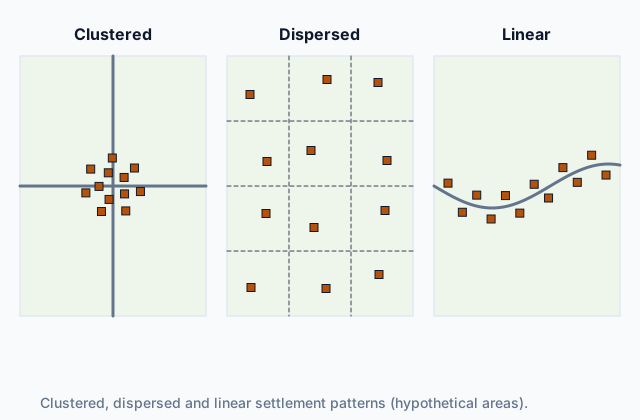 Tap to open the picture full size
Part 1 Think first Where will the families live?
Commit to a guess first. Being wrong now makes the right idea stick better.
Predict first
In a hypothetical river valley, families grow rice in flooded fields. The water comes from the river through canals the families must dig, clean and share, and planting and harvest need many hands at the same time. Where will the families most likely build their homes?
In short. Farming practices shape the rural landscape, and geographers read it in two ways: the settlement pattern, where farm families' homes stand relative to one another, and the survey method, how the land was measured and divided into properties.
- Specific agricultural practices shape rural land use: ranching leaves huge fenced pastures, market gardening small fields and greenhouses, plantation agriculture large blocks of one crop.
- Rural settlement patterns are classified as clustered (homes grouped in a village), dispersed (homes apart, each on its own farm) or linear (homes in a line along a road, river or canal).
- Rural survey methods include metes and bounds (boundaries from landmark to landmark), township and range (a grid of square-mile sections) and long lot (narrow strips running back from a river or road).
Part 2 Learn it Reading the rural landscape
2a. Farming shapes rural land use
Every farming practice leaves its own mark on the countryside: how big the fields are, what shape they take, where the buildings stand and how far apart the homes are. Geographers call this the rural land-use pattern, and they read it as a record of how people farm.
- Ranching needs huge areas of grass, so it leaves fenced pastures that stretch for miles, with a ranch house and corrals every few miles.
- Market gardening puts heavy work into a few acres, so its land is small fields and greenhouses packed close together near the city that buys the produce.
- Plantation agriculture plants one crop across large blocks of land, often with housing for its workers grouped near a mill or packing plant.
- A mixed crop-livestock farm surrounds its barns and animal pens with fields of feed crops such as corn and hay.
- Shifting cultivation leaves a patchwork in the forest: a few small clearings in use at any time, among many patches of regrowth of different ages.
The same practice also shapes where farm families live, which is the next idea.
Quick check · Match
Match each farming practice to the rural landscape it would leave in a hypothetical region.
2b. Clustered, dispersed and linear settlements
Rural settlement patterns are classified as clustered, dispersed or linear. The picture at the top of the page shows each one with the same 12 farmhouses.
In a clustered settlement, homes and other buildings are grouped together in a village or a smaller hamlet, and farmers go out each day to the fields around it. Families cluster when they share work that needs many hands, such as keeping canals running or bringing in a harvest, when they need to defend themselves, or to share a well, a market, a school or a place of worship.
In a dispersed settlement, farmhouses stand apart from one another, each on its own land, often far from the nearest neighbor. This pattern forms where each family owns and works its own farm and builds its house there.
In a linear settlement, homes line up along a road, river, canal, coastline or narrow valley floor, because the line gives what every family needs: transport, water or access to trade.
To classify a settlement, look at the distances between homes and at what the homes follow, not at how much land each family owns.
Quick check · Sort it
Each card describes the homes in a hypothetical farming area. Tap a card, then the settlement pattern it shows.
Clustered
Dispersed
Linear
2c. Metes and bounds and long lots
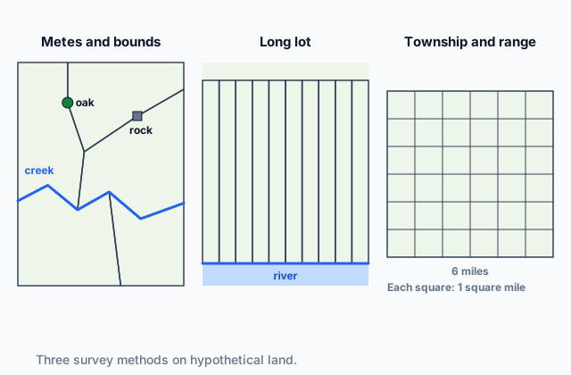
A survey method is the way land is measured and divided into properties. Rural survey methods include metes and bounds, township and range, and long lot, and each leaves lasting marks on the land: the shapes of fields, the lines between properties and the paths of roads.
Metes and bounds describes a property by its edge, from one landmark to the next: the directions and distances (the metes) and the natural and human features that mark the line (the bounds), such as trees, streams, rocks and walls. Parcels come out in uneven shapes that follow the land. Landmarks can die, move or vanish, so old boundaries are often disputed.
The long-lot method divides land into long, narrow strips that run back from a river, road or canal. Each farm gets a share of the frontage, so every family can reach the water or the road, and each strip crosses the different kinds of land behind it, from the bank back to the woods.
 Tap to open the picture full size
Quick check · Fill the statement
Complete the description of two rural survey methods.
Under , a property's boundary is traced from landmark to landmark, such as a tree, a bend in a stream or a stone wall, so its fields take shapes that follow the land. Under the long-lot method, each farm is a narrow strip with on a river or road, running far back from it.
2d. Township and range
Township and range is a survey laid out as a grid in advance of the land's sale. Its lines run north-south and east-west at fixed spacing, whatever hills or streams are in the way. They divide the land into townships, squares six miles on a side, and each township into 36 sections of one square mile, or 640 acres. A section can be split into four quarter sections of 160 acres each, and those into smaller squares again.
On the ground the grid shows as square fields and straight roads along the section lines, a mile apart. Because each piece of land is named by its place in the grid, it is easy to sell and record, and boundaries are rarely disputed. The figure in 2c shows a township beside the other two methods.
Where families each bought a quarter section and built a house on it, the grid spread homes evenly across the land, about half a mile apart.
Quick check · Decide and justify
A map of a hypothetical county shows square fields, and roads that run straight north-south and east-west one mile apart, crossing streams and hills instead of going around them. Which survey method laid out this county?
Which reason supports your answer?
Part 3 Watch it done How many farms fit in a township?
Watch each step, then do the last one yourself.
Hypothetical Prairie County was surveyed by township and range and sold to settlers in quarter sections of 160 acres, each family living on its own farm. How many farm families could one township hold?
Predict first
Before the steps, about how many families do you expect one township to hold?
Step 1 · Count the sections
A township is six miles on a side, divided into 6 × 6 = 36 sections of one square mile each.
Step 2 · Count the farms in one section
A section is 640 acres, so it holds 640 ÷ 160 = 4 quarter sections, four farms of 160 acres.
Why this step?
Why does selling the land this way give Prairie County a dispersed settlement pattern?
Each family lives on its own quarter section, so the farmhouses are spread evenly across the land, about half a mile apart, instead of grouped in a village or lined up along one road.
Your step · Calculate
Finish it. Using the two counts from the steps, how many farm families could one township of Prairie County hold?
families
Part 4 Try it Read a county's land
Try it · Multiple choice
In hypothetical Riviere County, the land was surveyed in long lots running back from the river, and each family built its house at the river end of its lot. What settlement pattern do the houses form?
Try it · Spot the error
A student describes the land use of hypothetical Forest District. Which line is the first to go wrong?
Part 5 Explain it Explain how rural land is settled and divided
Nothing you type leaves this page. Check your answer against the model and each scoring point.
Free response is 50% of the exam score. This one is shaped like Question 1, from free-response II.
Free-response practice · Question 1 style
Answer each part about rural settlement patterns and survey methods.
(A) Define a clustered rural settlement pattern.
(B) Describe the township and range survey method.
(C) Explain how the township and range survey method can produce a dispersed rural settlement pattern.
(D) Explain why a long-lot survey tends to produce a linear settlement pattern.
(E) Compare how metes and bounds boundaries and township and range boundaries relate to the physical features of the land.
(F) Explain how one specific agricultural practice shapes a rural land-use pattern.
(G) Explain one reason farm families in a region might live in a clustered settlement rather than each on its own farm.
Model answer
(A) A clustered settlement is one in which homes and other buildings are grouped together in a village or hamlet, with the farmland around it, and farmers travel out to their fields.
(B) Township and range divides land into a grid laid out in advance, with lines running north-south and east-west. The grid makes townships six miles on a side, each divided into 36 sections of one square mile, which can be split into quarter sections and smaller squares.
(C) Land was sold in separate square farms, such as quarter sections, and each family built its house on its own farm. The homes were spread evenly across the grid, each far from the next, instead of grouped in a village.
(D) Each long lot is a narrow strip with a short frontage on a river or road. Families build at the front of their lots to reach the water or the road, so the homes stand one after another in a line along it.
(E) Metes and bounds boundaries follow physical features, running from landmark to landmark along streams, trees and rocks, so parcels take uneven shapes. Township and range boundaries ignore physical features, running straight north-south and east-west at fixed spacing across hills and streams, so parcels are squares.
(F) Ranching needs a very large area of grass for its animals, so it divides the land into huge fenced pastures, with a few ranch buildings miles apart.
(G) Families may cluster to share work that needs many hands, such as keeping shared irrigation canals running, which is easier when everyone lives close to the canals and to one another.
Score your own answer. This is a self-check, not a grade. Tick each point your answer makes.
Part 6 Check yourself The three areas of Lake County
The case questions use the map and the table. The others mix the ideas from the whole lesson.
A planner for hypothetical Lake County mapped part of each of three rural areas from a recent aerial survey and counted the farms in each whole area.
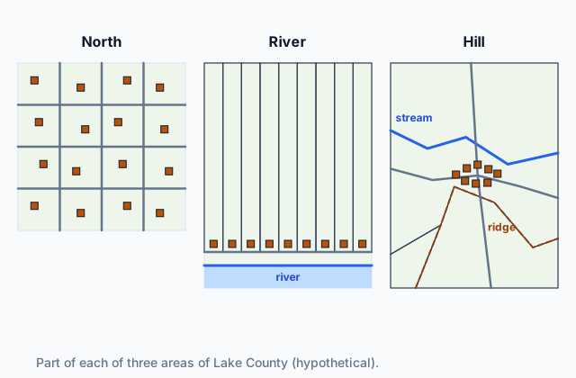 Tap to open the picture full size
| Area | Farms | Land |
|---|---|---|
| North | 96 | 7,680 acres |
| River | 40 | 4,000 acres |
| Hill | 30 | 3,600 acres |
Case question 1 · Multiple choice
Using the map, which survey method most likely set the Hill area's boundaries, and which settlement pattern do its farmhouses form?
Case question 2 · Calculate
What is the average size of a farm in the North area, in acres?
Case question 3 · Multiple choice
Which conclusion do the map and the table support?
The rest stand on their own and do not use the case.
Check yourself · Select all
Which two are reasons farm families in a hypothetical region might live in a clustered settlement rather than each on its own farm? Select two.
Select 2 answers, then check.
Check yourself · Sort it
Each card is part of a property description from a hypothetical county. Tap a card, then the survey method it comes from.
Metes and bounds
Township and range
Long lot
Part 7 Keep it Bring back earlier ideas
This lesson stands on the intensive and extensive farming practices of Topic 5.1.
From 5.1 Introduction to Agriculture · Rank it
Four hypothetical farms report their land and their yearly spending on inputs (labor, seed, feed, fertilizer and machines). Rank them from most intensive to least intensive. Work out the spending per acre for each farm before you rank.
Most intensive first
Give each one a place, 1 for first. Give two the same place if they are equal.
Your ranking: none yet
From 5.1 Introduction to Agriculture · Sort it
Each card describes a hypothetical farm or herd. Tap a card, then the extensive farming practice it shows.
Shifting cultivation
Nomadic herding
Ranching
In three lines
- Farming practices shape rural land use: the size and shape of fields, the buildings and the spacing of homes.
- Rural settlement patterns are clustered, dispersed or linear, read from where the homes stand.
- Survey methods include metes and bounds, township and range, and long lot, read from field shapes and property lines.
Exam strategy for this topic
- Section I, Multiple Choice: 60 questions in 60 minutes.
- Section II, Free Response: 3 questions in 75 minutes.
When a question shows a rural landscape, read two things separately: the shapes of fields and property lines, which point to a survey method, and where the homes stand relative to one another, which is the settlement pattern. Then tie each to a cause, such as a farming practice or the way land was sold.
Questions students ask
Is a long lot the same thing as a linear settlement?
No. A long lot is a survey method, a way of dividing land into narrow strips off a river or road. A linear settlement is a pattern of homes. Long lots often produce a linear settlement because families build at the front of their strips, but a linear settlement can also form along a road or coast with no long lots.
Why does township and range make square fields and straight roads?
Its lines were laid out as a grid, north-south and east-west at fixed spacing, in advance of the land's sale. Fields and roads followed the section lines, so they are square and straight even where hills or streams are in the way.
Which survey method leads to the most boundary disputes?
Metes and bounds, because its boundaries depend on landmarks such as trees and streams that can die, move or disappear. A township and range grid names each piece of land by its place in the grid, which is much harder to dispute.
What is the difference between clustered and dispersed settlement?
In a clustered settlement, homes are grouped together in a village or hamlet with the fields around it. In a dispersed settlement, homes stand apart, each on its own farm.
Are the counties and places in this lesson real?
No. Every county, valley, district and area here is hypothetical, with numbers chosen to show each idea clearly. The settlement patterns and survey methods are real, and you can find each of them in real landscapes.
Course alignment, for teachers
AP Human Geography topic 5.2, Unit 5: Agriculture and Rural Land-Use Patterns and Processes.
- Skill 4.D: Compare patterns and trends in visual sources to draw conclusions.
This lesson maps all 3 essential knowledge statements of the topic to the part that teaches each one: 3 are checked by a scored question. The map is in the lesson file.