Unit 5 · Topic 5.8 · about 30 minutes · 7 parts · 12 scored checks, 3 of them multiple choice, plus 2 from earlier lessons
AP Human Geography 5.8: Von Thünen Model
Unit 5: 12 to 17% of the multiple-choice section
What you'll be able to do
- Describe how von Thünen's model uses the cost of transporting farm products to a market to explain where different kinds of farming locate, apply it around one town, a whole country or the world, and explain why regions of specialty farming do not always fit its rings.
Key vocabulary
| Term | What it means | The exam trap |
|---|---|---|
| Von Thünen's model | A model of rural land use around a single market city, in which farmers choose each land use by what it earns there after the cost of carrying products to the market. | It rests on stated assumptions, so learn them along with the rings. |
| Transportation cost | What it costs to carry a product from the farm to the market. | The cost of hauling a hectare's crop grows with distance and with how many tonnes the hectare yields; the cost of hauling each tonne grows with distance alone. |
| Concentric rings | Rings that share one center, each inside the next; in von Thünen's model, the belts of land use around the market. | The model sets the order of the rings, not how wide each one is. |
| Specialty farming | Farming of a product that depends on a particular climate, soil or local skill, such as wine grapes or some fruits. | Name the local condition the product depends on when you use the term. |
| Rural land use | How land outside cities is used: for crops, livestock, forest or other purposes. | Forest is a rural land use too, not only farming. |
 Tap to open the picture full size
Part 1 Think first Where does the woodland go?
Commit to a guess first. Being wrong now makes the right idea stick better.
Predict first
Von Thünen's model sorts the land around a market city into rings, and one ring is woodland that supplies the city with firewood and building timber. Where do you think the model puts the woodland?
In short. Von Thünen's model explains rural land use by the cost of transporting farm products to a market: around one market city, each land use takes the distance where it earns the most after transportation costs, forming concentric rings, though regions of specialty farming do not always conform to them.
- The model assumes one market city, a flat plain with the same soil and climate everywhere, one way to travel, and farmers who choose the land use that earns the most.
- From the market outward, the rings are market gardening and dairy, then forest, then grains and field crops, then livestock ranching, each placed by how fast its profit falls with distance.
- The model can be applied around a town, a country's largest city or the world's big urban regions, and real rivers, roads, refrigeration and specialty crops tied to a climate or soil bend the rings.
Part 2 Learn it Distance, transportation cost and the rings
2a. Distance and transportation cost
In the early 1800s, Johann Heinrich von Thünen, a landowner who kept careful accounts of his estate, asked why land near a market town was farmed differently from land far away. Von Thünen's model answers with one factor: the transportation cost of getting each product from the farm to the market, which grows with distance.
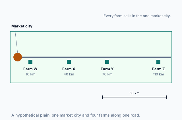
To see that factor on its own, he imagined an isolated region and assumed:
- one market city, where every farmer sells;
- a flat plain with the same soil and climate everywhere;
- one way to carry goods, by horse and cart, equally easy in every direction, with the cost rising with distance;
- farmers who choose the land use that earns them the most.
The picture at the top of the page shows that setting. With these assumptions, only distance separates Farm W from Farm Z. For every tonne a hectare yields, a farmer keeps the price, less the cost of growing it, less the cost of hauling it.
Take wheat that yields 3 tonnes a hectare, sells for $100 a tonne, costs $50 a tonne to grow and costs $0.50 a tonne for each kilometer to carry. At 10 km, each tonne keeps $45, or $135 a hectare. At 60 km it keeps $20, or $60 a hectare. At 100 km the haul takes the whole $50, and wheat earns nothing.
Quick check · Multiple choice
On a hypothetical plain where von Thünen's assumptions hold, two farmers grow wheat and sell it in the one market city. One farm is 10 km from the city and the other is 80 km away. In the model, why does the farther farmer earn less from each hectare?
2b. The four rings
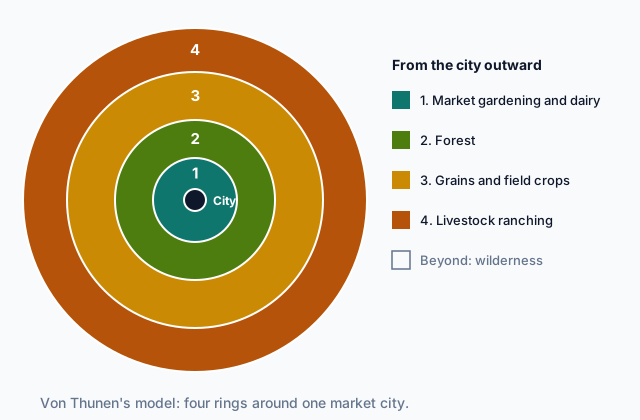
Because each product loses its profit to distance at its own rate, von Thünen's model sorts the land around the market into concentric rings.
 Tap to open the picture full size
- Ring 1, market gardening and dairy. Vegetables, soft fruit and milk spoil within a day or two, and a hectare yields many tonnes of them, so they must be close enough to reach the market fresh. They earn a lot from each hectare, so they can outbid every other use for the nearest land.
- Ring 2, forest. Wood for fuel and building is heavy and bulky, and the city needs a great deal of it, so it is costly to haul far.
- Ring 3, grains and field crops. Grain keeps for months and is cheaper to carry for its value, so it can be grown farther out, though it earns less from each hectare.
- Ring 4, livestock ranching. Animals walk themselves to market, and grazing needs a lot of land but earns little from each hectare.
Beyond the last ring, hauling costs more than any product earns, and the land is left wild. Farming becomes less intensive from the center outward: more work and money spent on each hectare near the market, less far away.
Quick check · Sort it
Tap a card, then the ring where von Thünen's model places that product.
Ring 1: market gardening and dairy
Ring 2: forest
Ring 3: grains and field crops
Ring 4: livestock ranching
2c. Why the rings form where they do
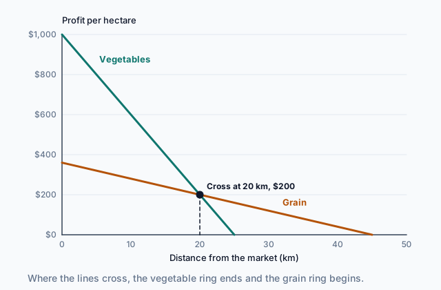
To find where one ring ends and the next begins, draw each land use's profit per hectare against distance from the market. Each line starts at what the use earns at the market and falls by its transportation cost for every kilometer.
 Tap to open the picture full size
In this hypothetical case with two land uses, vegetables start high but fall steeply: a hectare yields many tonnes of fresh produce, and every tonne pays for every kilometer. Grain starts lower but falls slowly. At each distance the farmer chooses the use that earns more, so vegetables hold the land out to 20 km, where the lines cross, and grain holds it from 20 km to 45 km.
The steepest line wins the nearest land, and the flattest line reaches farthest. Bid-rent theory, from Topic 5.6, describes the same pattern as what each land use can pay for land at each distance.
Quick check · Calculate
On a hypothetical plain, dairy farming earns $900 a hectare at the market and $25 less for each kilometer away from it. Grain earns $300 a hectare at the market and $5 less for each kilometer. At what distance from the market do the two earn the same, marking where the dairy ring ends and grain takes over?
2d. Scales, and where the rings break
The model works at more than one scale. Around one market town it explains a local pattern of farms. Around a country's largest city it can explain a regional or national one, with fresh produce and dairy close in and grain and ranching in the far provinces. At the global scale, the market becomes the world's big urban regions, which buy grain and beef from distant continents while land nearer them grows fresh produce.
Real regions bend the rings. A river, a highway or a rail line makes hauling cheaper in one direction, so a ring stretches along it. Refrigerated trucks and air freight cut the cost and time of carrying fresh goods. Hills, poor soils and different climates break the uniform plain.
Regions of specialty farming do not always conform to von Thünen's concentric rings. Wine grapes need particular slopes, soils and sunshine, and some fruits grow well only where frost is rare. Products like these are grown where their conditions are, sometimes far from the market, and many sell for a high price for each tonne, so a long haul costs them little. The model still explains much rural land use. A specialty region is a place where something besides transportation cost decides.
Quick check · Spot the error
A student applies von Thünen's model to a hypothetical country. Which line is the first to go wrong?
Part 3 Watch it done Wheat or cattle at Farm Y?
Watch each step, then do the last one yourself.
Farm Y, in the picture at the top of the page, is 70 km from the market city on a plain where von Thünen's assumptions hold. Its owner can grow wheat or raise beef cattle. Wheat yields 3 tonnes a hectare, sells for $160 a tonne, costs $70 a tonne to grow, and costs $1.00 a tonne for each kilometer to carry. Beef yields 0.5 tonnes a hectare, sells for $600 a tonne, costs $400 a tonne to raise, and costs $0.40 a tonne for each kilometer, as the cattle walk to market. Which earns more on each hectare at Farm Y?
Predict first
Before the steps, which do you expect to earn more on each hectare at Farm Y?
Step 1 · Write the profit for one hectare
Profit per hectare = yield × (price, less the cost to grow, less the transport cost per kilometer × the distance). Transport is paid on every tonne, so it comes off each tonne before you multiply by the yield.
Step 2 · Work out wheat at 70 km
Transport: $1.00 × 70 = $70 a tonne. Each tonne keeps $160 less $70 less $70, or $20. Three tonnes a hectare give $60 a hectare.
Why this step?
Why does a 70 km haul take so much more from wheat than from cattle?
Wheat is bulky and must be carted, so it pays more for every tonne and every kilometer, and a hectare yields many tonnes to carry. Cattle walk to market, carry a high value in each tonne, and a hectare yields few tonnes.
Your step · Calculate
Finish it. Beef yields 0.5 tonnes a hectare, sells for $600 a tonne, costs $400 a tonne to raise, and costs $0.40 a tonne for each kilometer to bring to market. What is the profit per hectare from beef cattle at Farm Y, 70 km from the market?
dollars per hectare
Part 4 Try it Use the model on new ground
Try it · Decide and justify
Around hypothetical City M, the dairy farms reach about 20 km out, and grain fields lie beyond them. A new highway with refrigerated trucks halves the cost of carrying milk to City M, and the cost of carrying grain does not change. What will most likely happen to the dairy belt?
Which reason supports your answer?
Try it · Match
Each observation comes from a hypothetical place. Match each scale or case of von Thünen's model to the observation that shows it.
Part 5 Explain it Explain a region's farm belts
Nothing you type leaves this page. Check your answer against the model and each scoring point.
Free response is 50% of the exam score. This one is shaped like Question 2, from free-response II.
Free-response practice · Question 2 style
Stimulus, a hypothetical land-use map of the region around City C, the largest city of hypothetical Country V, given here as its legend. The land is mostly flat.
- Vegetable and dairy farms: within about 20 km of City C
- Woodland: 20 to 40 km
- Wheat and barley fields: 40 to 110 km
- Cattle grazing: 110 to 250 km
- Along the highway running east from City C: vegetable and dairy farms out to about 60 km
- Hills 180 km northwest of City C: a district of vineyards
(A) Identify the land use the map shows closest to City C.
(B) Describe the role of transportation cost in von Thünen's model.
(C) Explain why the wheat and barley fields lie farther from City C than the dairy farms.
(D) Explain why vegetable and dairy farms reach farther from City C along the highway than in other directions.
(E) Explain why the vineyard district does not conform to von Thünen's model.
(F) Describe one way von Thünen's model can be applied at a scale larger than one city and the farms around it.
(G) Explain one limitation of von Thünen's model for explaining farming today.
Model answer
(A) Vegetable and dairy farming, market gardening and dairy.
(B) In the model, every farmer pays to carry products to the one market, and the cost grows with distance. The farther a farm is from the market, the less profit it keeps from each sale, so each distance ends up with the land use that earns the most there after transportation costs.
(C) Fresh vegetables and milk spoil quickly, and a hectare yields many tonnes of them, so their profit falls fast with distance and they must be near the market. Wheat and barley keep well and cost less to carry for their value. They earn less per hectare at the market, but their profit falls slowly, so they earn more than dairy farther out.
(D) The highway lowers the cost and time of carrying fresh goods to City C. Along it, dairy and vegetables stay the most profitable use farther out than in directions without the highway, so their belt stretches along the road.
(E) The vineyards are specialty farming. Wine grapes need the slopes, soils and sunshine of those hills, and wine keeps well and sells for a high price for each tonne, so hauling it 180 km costs it little. Regions of specialty farming do not always conform to von Thünen's rings.
(F) At the global scale, a world region with many large cities can be treated as the market. Fresh produce and dairy for it are grown nearby, while grain and beef for it come from farms on distant continents, an outer ring at world scale.
(G) The model assumes one market and travel by cart at the same cost in every direction. Today trucks, rail, refrigeration and air freight make transport fast and cheap, and farmers sell to many markets, so distance from one city explains less of where crops are grown.
Score your own answer. This is a self-check, not a grade. Tick each point your answer makes.
Part 6 Check yourself The farm belts around City H
The case questions use the table. The others mix the ideas from the whole lesson.
A planning office in hypothetical Country N mapped the main land use around City H, the country's only large market. Most of the region is flat, with similar soils.
| Zone | Distance from City H | Main land use |
|---|---|---|
| A | 0 to 15 km | Vegetables, soft fruit and dairy |
| B | 15 to 35 km | Woodland for timber and fuel |
| C | 35 to 90 km | Wheat and barley |
| D | 90 to 200 km | Cattle and sheep grazing |
| E | 170 km, a frost-free valley in the hills | Orchards of a pear that ripens only in frost-free valleys, sent to City H by refrigerated rail |
In Zone C, wheat sells in City H for $160 a tonne, costs $80 a tonne to grow, and costs $0.80 a tonne for each kilometer to carry to the city. A hectare yields 3 tonnes.
Case question 1 · Multiple choice
Which statement best explains why Zone A, not Zone C, holds the region's vegetable and dairy farms?
Case question 2 · Calculate
Using the Zone C wheat figures, at what distance from City H would a hectare of wheat stop earning any profit at all?
Case question 3 · Multiple choice
What does Zone E show about von Thünen's model?
The rest stand on their own and do not use the case.
Check yourself · Rank it
On a hypothetical plain, each land use earns this profit per hectare at the market and loses this much for each kilometer away from it: dairy, $1,000 and $25; forest, $600 and $10; grain, $360 and $4; ranching, $120 and $1. Work out each profit at 50 km, then rank the land uses by profit per hectare on a farm 50 km from the market.
Highest profit first
Give each one a place, 1 for first. Give two the same place if they are equal.
Your ranking: none yet
Check yourself · Select all
Which two features would make a hypothetical region's farming fit von Thünen's rings less well? Select two.
Select 2 answers, then check.
Part 7 Keep it Bring back earlier ideas
This lesson stands on earlier Unit 5 topics on production regions and on how economic forces shape farming.
From 5.6 Agricultural Production Regions · Calculate
Around a hypothetical city, market gardening can bid 1,800 dollars per hectare per year at the market, and its bid falls by 90 dollars for each kilometer away. Wheat farming can bid 600 dollars at the market, and its bid falls by 15 dollars per kilometer. Beyond what distance from the market does wheat farming outbid market gardening?
From 5.7 Spatial Organization of Agriculture · Fill the statement
Complete the description of how farm technology has changed the advantage of farm size.
A self-steering combine has a yearly cost to own and run. Its cost for each tonne of grain is therefore on a farm that harvests many hectares than on a farm that harvests few, so machines like it give farms a cost advantage.
In three lines
- Von Thünen's model explains rural land use by transportation cost rising with distance from one market.
- From the market outward: market gardening and dairy, forest, grains and field crops, then livestock ranching.
- The model applies at local, national and global scales, but regions of specialty farming do not always conform to the rings.
Exam strategy for this topic
- Section I, Multiple Choice: 60 questions in 60 minutes.
- Section II, Free Response: 3 questions in 75 minutes.
When a question shows a land-use pattern around a city, name the land use, its distance from the market, and how transportation cost explains it. When a place breaks the rings, name the assumption it breaks or the local condition it depends on.
Questions students ask
Who was von Thünen?
Johann Heinrich von Thünen was a landowner of the early 1800s who kept detailed records of his estate's costs and used them to build his model. He made simplifying assumptions so that the effect of distance from the market could be seen on its own.
Why is forest so close to the city in the model?
In von Thünen's time a city burned and built with large amounts of wood, which is heavy and bulky to carry by cart. Hauling it far cost too much, so the model places forest in the second ring, just beyond the fresh goods that had to reach the market quickly.
Is von Thünen's model the same as bid-rent theory?
They are related. Both find that land near the market goes to the uses that earn the most there. Bid-rent theory, from Topic 5.6, frames it as what each use can pay for land; von Thünen's model frames it as transportation cost by distance.
Does the model still work with trucks and refrigeration?
Partly. Fast, cheap transport stretches and blurs the rings, and farms now sell to many markets. But fresh, perishable goods are still often grown near large cities, and the cost of reaching a market still shapes much rural land use.
Are the places in this lesson real?
No. Every city, farm, zone and country here is hypothetical, with numbers chosen to show the model clearly. Real regions fit the rings more loosely.
Course alignment, for teachers
AP Human Geography topic 5.8, Unit 5: Agriculture and Rural Land-Use Patterns and Processes.
- Skill 5.B: Explain spatial relationships across various geographic scales using geographic concepts, processes, models, or theories.
This lesson maps the one essential knowledge statement of the topic to the part that teaches each one: 1 is checked by a scored question. The map is in the lesson file.