Unit 6 · Topic 6.11 · about 30 minutes · 7 parts · 12 scored checks, 3 of them multiple choice, plus 2 from earlier lessons
AP Human Geography 6.11: Challenges of Urban Sustainability
Unit 6: 12 to 17% of the multiple-choice section
What you'll be able to do
- Describe how well different attempts to meet the challenges of urban sustainability work: what each response achieves, what evidence shows it, and where it falls short.
Key vocabulary
| Term | What it means | The exam trap |
|---|---|---|
| Urban sustainability | A city's ability to meet its residents' needs now without using up the land, water, air and energy that later residents will need. | It joins environmental problems and land-use problems, so name the specific challenge a question describes instead of saying "sustainability" alone. |
| Suburban sprawl | Low-density growth that spreads outward from a city's edge, with homes set apart from jobs and shops and most trips made by car. | A growing population is not the same thing; the term is about how the growth uses land. |
| Sanitation | The safe collection, treatment and disposal of sewage and garbage. | It is a system of pipes, plants and trucks a city must build and run, not only how clean the streets look. |
| Climate change | A long-term change in temperatures and weather patterns, driven mainly by greenhouse gases released by burning fuel. | Cities both add to it and suffer from it, so say which side a question is asking about. |
| Air and water quality | How clean a city's air, streams, lakes and drinking water are, judged by the pollutants in them. | Pollution reaches water from paved streets and lawns as well as from pipes and factories. |
| Ecological footprint | The area of productive land and water needed to supply what a population consumes and to absorb its wastes. | Count the land for wastes and carbon too, not only the land for food and water. |
| Energy use | The fuel and electricity a city's people use for travel, heating, cooling and running buildings. | How a city is laid out shapes its energy use, not only what machines its people own. |
| Regional planning | Planning in which the governments of a metro area or region agree on land use, transit, water and sewers across their borders. | Check whether the governments are bound by the plan or only advised by it. |
| Brownfield | An abandoned or underused industrial or commercial site where real or suspected contamination makes reuse harder. | Suspected contamination counts, so a site can be a brownfield before any test confirms pollution. |
| Remediation and redevelopment | Remediation is cleaning up a contaminated site's soil and water; redevelopment is putting the site to a new use. | They are two steps, and a site can be cleaned up and still sit empty. |
| Urban growth boundary | A line around a city or metro area that separates land where development is allowed and served from land kept for farms and open space. | It controls where building goes, not how many people move to the city. |
| Farmland protection policy | A rule or program, such as agricultural zoning or the purchase of development rights, that keeps particular farmland from being developed. | A question can describe one of these tools, such as buying development rights, without ever saying "farmland protection". |
 Tap to open the picture full size
Part 1 Think first How much land does a city need?
Commit to a guess first. Being wrong now makes the right idea stick better.
Predict first
A hypothetical city of 500,000 people covers 200 square kilometers. Now picture all the farmland, forest, water and other land it takes to grow the city's food, supply its water and energy, and soak up its waste and the carbon it gives off. How does all that land compare with the city's own 200 square kilometers?
In short. Urban sustainability is a city's ability to meet its people's needs now without using up the land, water, air and energy that later residents will need.
- The challenges include suburban sprawl, sanitation, climate change, air and water quality, the large ecological footprint of cities, and energy use, and they feed one another: sprawl adds driving, driving adds exhaust and greenhouse gases.
- Responses include regional planning efforts, the remediation and redevelopment of brownfields, urban growth boundaries, and farmland protection policies.
- Judge a response by its goal, by the evidence before and after, and by what it pushes somewhere else, such as building that jumps past a boundary into the next town.
Part 2 Learn it Six challenges and four responses
2a. Sprawl, energy use and the ecological footprint
Urban sustainability means meeting a city's needs today without using up the land, water, air and energy its future residents will need. Three of the challenges to it come from how far a city spreads and reaches.
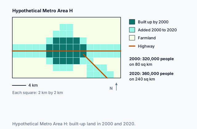
Suburban sprawl is low-density growth spreading outward from a city's edge: houses on large lots, set apart from shops and jobs, on roads built for cars. The picture at the top of the page shows it in hypothetical Metro Area H, where the built-up land tripled while the population grew by an eighth. Sprawl turns farmland and forest into subdivisions, and every new street needs new pipes, wires and roads.
Sprawl raises energy use. People in spread-out suburbs drive farther for every errand, and detached houses lose more heat through their walls and roofs than apartments that share them. Dense neighborhoods fill trains and buses, and walking works there.
A city's ecological footprint is the area of productive land and water needed to supply what its people consume and to absorb what they throw away. A city covers a small patch of ground, but its footprint takes in farms, reservoirs, mines and forests far beyond its limits. That reach is what makes the ecological footprint of a city so large.
Quick check · Calculate
A hypothetical city has 400,000 residents and covers 40,000 hectares. Researchers estimate that each resident needs 5 hectares of productive land and water to supply what they consume and absorb their waste. The city's ecological footprint is how many times the city's own area?
2b. Sanitation, air and water, and a changing climate
The other three challenges come from what a city sends into its surroundings.
Sanitation is the safe collection, treatment and disposal of sewage and garbage. When a city grows faster than its sewer lines and garbage trucks can reach, waste piles up in streets and lots, and disease spreads. Building and running these systems is one of the costliest jobs a city has.
Air and water quality fall as a city grows unless it acts. Car exhaust, factories and power plants put soot and gases into the air, and on still days they hang over the city as smog. Rain washes oil, salt and litter off pavement into streams, and sewage that leaks or overflows reaches the rivers and lakes the city drinks from.
Climate change reaches cities in two ways. Cities burn a large share of the fuel that releases greenhouse gases, in their cars, buildings and power plants. And cities feel its effects: pavement and roofs hold heat, so heat waves hit hardest downtown, and waterfront districts flood more often as seas rise and storms strengthen.
The six challenges feed one another. Sprawl adds driving, driving adds exhaust and greenhouse gases, and more pavement sends more polluted runoff into the water.
Quick check · Sort it
Each card describes a problem in a hypothetical city. Tap a card, then the challenge to urban sustainability it shows most directly.
Sanitation
Air quality
Water quality
Climate change
Energy use
2c. Steering growth: growth boundaries and farmland protection
Cities respond to these challenges in several ways. The two in this chunk decide where new building may go.
An urban growth boundary is a line drawn around a city or metro area. Inside it, new housing, stores and offices are allowed and served with water and sewer lines; outside it, land is kept for farms, forests and open space. A boundary that works pushes growth inward, onto empty lots and older sites where roads and pipes already exist, and new homes are built closer together. Less land is paved, trips are shorter and fewer new pipes are needed. It has limits. If land inside runs short, housing prices rise. And a boundary binds only the government that drew it, so builders can jump past it to the next town or county.
Farmland protection policies keep particular farms in farming. A county can zone land for agriculture only, pay farmers for their right to develop it (a purchase of development rights), accept a permanent easement that bars building on it, or tax farmland at a lower rate while it stays farmed. Fields whose development rights are bought or placed under an easement stay open for good; zoning can be changed later, and a tax break ends when the land is sold for building. But buying development rights costs a great deal, most programs are voluntary, and an unprotected farm next door can still be sold for houses.
Quick check · Fill the statement
Complete the description of two responses to suburban sprawl in a hypothetical county.
The county draws an urban growth boundary, so new subdivisions are allowed only the line. Growth that cannot spread outward goes into the older towns instead, which makes those towns . The county also pays farmers for their right to develop their fields, a policy that keeps those fields in farming even if the boundary is later moved.
2d. Working across borders and reusing land: regional planning and brownfields
A metro area is usually split among many cities, towns and counties, and each one zones its own land, the fragmentation of governments Topic 6.10 describes. One town can approve a large subdivision whose traffic, runoff and smog spill into its neighbors. Regional planning efforts bring these governments together behind one plan for land use, transit, water and sewers across the whole metro area. They work when members agree to follow the plan; a plan any town can ignore changes little.
A brownfield is an abandoned or underused industrial or commercial site, such as an old factory, rail yard or gas station, where real or suspected contamination makes reuse harder. Remediation cleans up its soil and water; redevelopment then puts the site to a new use, such as housing, offices or a park. Building on a cleaned-up brownfield uses roads and pipes already in place, removes a source of pollution and takes pressure off farmland at the edge. But cleanup is slow and costly, and builders fear being held liable for pollution they did not cause, so many sites sit idle without public money.
To judge any response, ask what goal it targets, what the evidence shows before and after, and what it pushes somewhere else.
Quick check · Multiple choice
Seven hypothetical towns share one river valley, and each town makes its own land-use rules. New subdivisions in the largest town send traffic and stormwater runoff into the six others. Which response is aimed at this problem?
Part 3 Watch it done Did the growth boundary save farmland?
Watch each step, then do the last one yourself.
Hypothetical Ridge County drew an urban growth boundary around its towns. Its neighbor, hypothetical Lake County, drew none. In the ten years before the boundary, Ridge County lost an average of 800 hectares of farmland a year to development, and Lake County lost 200. In the ten years after, Ridge County lost 300 hectares a year, and Lake County lost 500. Describe how effective the boundary was at protecting farmland in the two-county region.
Predict first
Before the steps, how well do you expect the boundary worked for the two counties together?
Step 1 · Name the goal and the evidence
A growth boundary aims to slow sprawl onto farmland, so the evidence to read is hectares of farmland lost each year, before and after the boundary.
Step 2 · Look where the boundary applies
In Ridge County, the loss fell from 800 to 300 hectares a year. That is a drop of 500, and 500 ÷ 800 = 62.5 percent. Judged on Ridge County alone, the boundary looks very effective.
Why this step?
Why look at Lake County at all, when the boundary is in Ridge County?
A boundary limits building only where the government that drew it has power. Builders kept out of Ridge County's farmland can buy land just across the county line, and Lake County's loss rose from 200 to 500 hectares a year. That rise has to be weighed against what Ridge County saved.
Your step · Calculate
Finish it. Add the two counties' farmland lost per year before the boundary, and again after it. By what percent did farmland loss across the two-county region fall?
percent
Part 4 Try it Choose the response
Try it · Match
A hypothetical metro area is trying four responses to its sustainability challenges. Match each response to the action that carries it out.
Try it · Decide and justify
Hypothetical City W loses about 600 hectares of farmland a year to new subdivisions at its edge. Inside the city, 90 hectares of closed factories and rail yards with contaminated soil sit empty, beside roads, sewers and a rail line already in use. The council can fund one project this year. Which does more to reduce suburban sprawl?
Which reason supports your answer?
Part 5 Explain it Explain how a metro area can grow sustainably
Nothing you type leaves this page. Check your answer against the model and each scoring point.
Free response is 50% of the exam score. This one is shaped like Question 1, from free-response II.
Free-response practice · Question 1 style
A hypothetical metro area of 2,000,000 people is spreading outward. Subdivisions of houses on large lots are replacing farms at its edge, its residents drive farther each year, and its old industrial district is full of closed factories. Each of its 15 local governments makes its own land-use rules.
(A) Define suburban sprawl.
(B) Describe one way suburban sprawl increases a metro area's energy use.
(C) Explain why a city's ecological footprint is much larger than the area the city covers.
(D) Describe one challenge to urban sustainability, other than sprawl, energy use and the ecological footprint, that rapid growth creates for a metro area.
(E) Explain how the remediation and redevelopment of brownfields in the industrial district could reduce the loss of farmland at the metro area's edge.
(F) Explain one limitation of an urban growth boundary drawn by only one of the 15 local governments.
(G) Explain how a regional planning effort could make an urban growth boundary more effective in this metro area.
Model answer
(A) Suburban sprawl is low-density growth that spreads outward from a city's edge, with homes on large lots set apart from shops and jobs, so most trips are made by car.
(B) Homes in sprawling suburbs are far from work, school and stores, so residents drive longer distances for each trip and burn more fuel. Detached houses also lose more heat than apartments that share walls, so they need more energy to heat and cool.
(C) The ecological footprint counts all the productive land and water needed to supply a city's food, water, energy and materials and to absorb its waste and carbon. A city grows almost none of its own food and makes little of its own energy, so most of that land lies on farms, in reservoirs and in forests far outside the city.
(D) Sanitation: when the metro area grows faster than its sewer lines and garbage collection, waste is left untreated or uncollected in new neighborhoods, which spreads disease and pollutes streams.
(E) Cleaned-up brownfields are building sites inside the metro area that already have roads, water and sewer lines. Homes and offices built there take in growth that would otherwise spread onto farms at the edge, so less farmland is converted.
(F) A boundary binds only the government that drew it. Builders kept out of that town's farmland can build just across its border in one of the other 14, so the farmland loss moves instead of falling.
(G) A regional plan adopted by all 15 governments can draw one boundary around the whole metro area. Builders can no longer move just across a town line to escape it, so more growth goes inward, and the governments can also plan transit and sewers to serve the denser areas inside the line.
Score your own answer. This is a self-check, not a grade. Tick each point your answer makes.
Part 6 Check yourself Two metro areas, one population
The case questions use the table. The others mix the ideas from the whole lesson.
Hypothetical Metro Area N and hypothetical Metro Area S each have 1,200,000 people. A state agency published these figures for last year. Every number is invented for this lesson.
| Measure | Metro Area N | Metro Area S |
|---|---|---|
| Population | 1,200,000 | 1,200,000 |
| Built-up area | 480 sq km | 1,500 sq km |
| Average distance driven per resident per day | 16 km | 38 km |
| Farmland converted to development | 250 hectares | 1,900 hectares |
| Days with unhealthy air | 8 | 27 |
| How land-use rules are made | One regional plan with an urban growth boundary, adopted by all 12 local governments | Each of its 20 local governments makes its own rules |
Case question 1 · Multiple choice
Which statement about the two metro areas does the table best support?
Case question 2 · Calculate
How many people live in each square kilometer of Metro Area S's built-up area?
Case question 3 · Multiple choice
Metro Area S's leaders want to cut the farmland it converts each year without pushing new building from one of its towns into another. Which response best fits that goal?
The rest stand on their own and do not use the case.
Check yourself · Spot the error
A student judges a hypothetical city's urban growth boundary. Which line is the first to go wrong?
Check yourself · Select all
A hypothetical county's farmland protection policy buys the development rights of farmers who volunteer to sell them. Which two are limitations of this policy? Select two.
Select 2 answers, then check.
Part 7 Keep it Bring back earlier ideas
This lesson stands on Topic 6.10's urban challenges and Topic 6.9's urban data.
From 6.10 Challenges of Urban Changes · Multiple choice
In a hypothetical city, a district along an old rail line has two thirds fewer residents than in 1990. Home values there have fallen by half, lenders turn down loans for the district, and its empty lots are used for illegal dumping. Which term best names this district?
From 6.9 Urban Data · Decide and justify
A hypothetical city plans a new rail station in one of its neighborhoods. Before it builds, the planning office wants to learn how long-time residents of that neighborhood feel about the station. Which data should the office gather?
Which reason supports your answer?
In three lines
- Challenges: suburban sprawl, sanitation, climate change, air and water quality, a large ecological footprint and energy use, each feeding the others.
- Responses: regional planning efforts, brownfield remediation and redevelopment, urban growth boundaries and farmland protection policies.
- Judge a response by its goal, the evidence before and after, its costs, and what it pushes somewhere else.
Exam strategy for this topic
- Section I, Multiple Choice: 60 questions in 60 minutes.
- Section II, Free Response: 3 questions in 75 minutes.
When a question asks how effective a response is, name its goal, give one thing it achieves with evidence, and give one limit, including where the problem could move, such as across a border to a town the response does not cover.
Questions students ask
What is the difference between an urban growth boundary and a farmland protection policy?
A growth boundary is one line around a city or metro area that decides where building may go. A farmland protection policy works farm by farm, through zoning, buying development rights, easements or lower taxes, to keep particular fields in farming. Many places use both.
Does a brownfield have to be polluted?
It has real or suspected contamination. Even the suspicion makes buyers, lenders and builders wary, which is why many brownfields sit empty until someone tests and cleans them.
Why does sprawl use more energy?
Homes far from jobs and stores mean longer car trips, and transit has too few riders to run often at low density. Detached houses also lose more heat than apartments that share walls.
Is climate change a cause or an effect of how cities work?
Both. Cities burn much of the fuel that releases greenhouse gases, and they face its effects, such as hotter heat waves downtown and more flooding along their waterfronts.
Are the places and numbers in this lesson real?
No. Every city, county, metro area and number here is hypothetical, chosen to show each challenge and response clearly. Real places show these patterns more loosely.
Course alignment, for teachers
AP Human Geography topic 6.11, Unit 6: Cities and Urban Land-Use Patterns and Processes.
- Skill 2.D: Explain the significance of geographic similarities and differences among different locations and/or at different times.
This lesson maps all 2 essential knowledge statements of the topic to the part that teaches each one: 2 are checked by a scored question. The map is in the lesson file.